
Aug 13, 2026
What Are the Top DJI Enterprise Mapping Bundles for Surveying?
Hardware choices directly dictate field survey efficiency, positional accuracy, and commercial margins. Selecting an mismatched platform introduces unnecessary field friction, extends processing times, and inflates administrative overhead. This technical breakdown evaluates the premier DJI Enterprise mapping bundles available today to help UK operators optimize field acquisition, data throughput, and regulatory compliance.
Which DJI Drone Ecosystem Bundles Lead Commercial Mapping Operations?
The DJI Matrice 4E Survey Combo, the Matrice 350 RTK Geospatial Bundle, and the Mavic 3 Enterprise RTK Package represent the gold standard for commercial surveying applications. Each hardware ecosystem addresses distinct site conditions, scale requirements, and positional accuracy thresholds across civil engineering, mining, and geospatial projects.
Operational insights show that choosing between a compact platform and a heavy-lift rig depends on ground coverage per flight, sensor physics, and transport logistics.
1. The Matrice 4E Survey Combo (Next-Gen Compact Standard)
The Matrice 4E (M4E) redefines small-footprint mapping by pairing a 20 MP 4/3 CMOS sensor with a mechanical shutter and an integrated RTK module. Mechanical shutter speeds of 0.5 seconds eliminate rolling-shutter distortion during high-speed mapping passes, allowing forward flight speeds up to 21 m/s without sacrificing spatial precision.
The complete ecosystem bundle consists of:
-
Matrice 4E Aircraft featuring an integrated RTK Module and AI compute unit
-
DJI RC Plus 2 Enterprise Controller with O4 transmission and high-gain antenna
-
D-RTK 3 Multifunctional Station operating as a base station, checkpoint rover, or signal relay[cite: 1, 2]
-
1-Year DJI Terra License and DJI Care Enterprise Plus Cover
-
20 MP 4/3 CMOS Wide Camera alongside Medium Tele and Tele lenses
-
Max flight time of 49 minutes with an O4 transmission range up to 25 km
2. The Matrice 350 RTK Geospatial Heavy-Lift Bundle (Vast Scale & LiDAR)
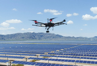
For vast infrastructure corridor mapping, complex topography, or combined photogrammetry and aerial LiDAR, the Matrice 350 RTK (M350 RTK) remains the industry workhorse. Equipped with IP55 weather protection, dual-battery redundancy, and support for interchangeable gimbals like the Zenmuse P1 (45 MP full-frame photogrammetry) and the Zenmuse L3 (long-range 1535nm LiDAR), this platform handles demanding environments.
The flagship heavy-lift bundle includes:
-
Matrice 350 RTK Airframe supplied with the BS65 Intelligent Battery Station
-
Zenmuse P1 Full-Frame Sensor or Zenmuse L3 Aerial LiDAR System
-
DJI RC Plus Controller supporting dual-control operating modes
-
D-RTK 2 Mobile Station or Network RTK/NTRIP integration
-
Maximum payload capacity of 2.7 kg supporting single upward and dual downward gimbals
-
IP55 ingress protection with up to 55 minutes of unladen flight time
3. The Mavic 3 Enterprise (M3E) RTK Keep-Flying Kit (Lightweight Precision)
The Mavic 3 Enterprise established the benchmark for lightweight, rapid-deployment surveying. While complemented in feature density by the Matrice 4 Series, the M3E bundle remains a cost-effective platform for smaller site surveys, stockpile volume calculations, and earthworks progress monitoring.
The portable survey kit features:
-
Mavic 3 Enterprise Aircraft featuring a 20 MP 4/3 CMOS sensor with mechanical shutter
-
Clip-on M3E RTK Module and RC Pro Enterprise Controller
-
Battery Charging Hub paired with 3x Intelligent Flight Batteries
-
Rapid 0.7-second mechanical shutter trigger interval
-
Sub-1kg airframe weight (915g) offering a 45-minute maximum flight time
How Does the Matrice 4E Compare to the Mavic 3 Enterprise for Survey Workflows?
Data highlights substantial generational leaps in trigger speed, mission automation, and positioning capabilities when comparing the Matrice 4E to the Mavic 3 Enterprise. The M4E upgrades camera trigger frequency from 0.7 seconds down to 0.5 seconds. Combined with an increased forward mapping speed of 21 m/s (compared to the M3E's 15 m/s), the M4E covers larger survey areas per flight battery while maintaining dense image overlap.
Key platform specifications illustrate the evolution across compact survey hardware:
-
Sensor Specs: Both platforms utilize a 20 MP 4/3 CMOS wide camera, but the M4E adds factory-calibrated optics.
-
Shutter Performance: The M3E triggers at 0.7-second intervals, whereas the M4E fires at 0.5-second intervals.
-
Flight Speed: The M3E tops out at 15 m/s in mapping modes, while the M4E maps at up to 21 m/s.
-
Maximum Endurance: Flight times increase from 45 minutes on the M3E to 49 minutes on the M4E.
-
Transmission Ecosystem: Upgraded from O3 Enterprise on the M3E to O4 Enterprise (25 km range) on the M4E.
-
Ground Positioning: The M3E pairs with the D-RTK 2, while the M4E integrates natively with the multi-mode D-RTK 3 Base/Rover station.
Onboard Computing and Edge 3D Modeling
The Matrice 4E introduces onboard computing upgrades via the RC Plus 2 Enterprise controller and integrated aircraft processing. Pilots can run Smart 3D Capture to build lightweight point clouds directly on the remote controller in the field without exporting raw files to a desktop workstation.
This on-site model allows operators to auto-generate precise, collision-free 3D capture routes over complex assets before launching a secondary detailed inspection pass.
Advanced Oblique Capture Modes
-
5-Directional Oblique Capture: Replaces standard cross-hatch flight grids by dynamically gimbaling the single camera array left, right, forward, backward, and nadir on a single flight leg. This slashes field capture times for 3D modeling and building facade surveys.
-
3-Directional Oblique Capture: Sweeps wide corridors and terrain with elevation changes, achieving high-density side overlap while reducing total photo count and subsequent photogrammetry processing overhead in software like DJI Terra.
What Field Hardware Capabilities Matter for High-Precision Site Surveys?
Achieving survey-grade results depends on sensor mechanics, distortion correction, and GNSS positioning stability. Mechanical shutters are mandatory for commercial photogrammetry. Electronic rolling shutters capture pixel rows sequentially, which introduces micro-skewing at high velocities that degrades bundle block adjustment during photogrammetric reconstruction.
Key findings reveal the core technological pillars that drive field precision:
Sensor Physics and Factory Distortion Calibration
The Matrice 4E features Factory Distortion Correction 2.0. Each lens parameter is measured during manufacturing and written directly into the XMP metadata of captured images. When imported into DJI Terra or third-party photogrammetry engines, image distortion is automatically removed without requiring extensive manual Ground Control Point (GCP) alignment.
Ground Control Points vs. Base Station Centimeter Positioning
While RTK positioning reduces the total number of Ground Control Points required on site, professional surveyors deploy independent Checkpoints to validate model geometry.
The D-RTK 3 Multifunctional Station serves three distinct operational roles:
-
Mobile Base Station: Transmits differential corrections directly to the Matrice 4E via O4 Enterprise transmission in cellular dead zones.
-
Ground Checkpoint Rover: Connects via Bluetooth to the DJI Enterprise Mobile App, allowing surveyors to log precise Ground Control Points and Checkpoints before flight.
-
O4 Signal Relay: Acts as a physical transmission relay when flying behind structural obstructions or inside deep open-cast mines, extending signal range significantly.
How Do Dronedesk Software and Shop Solutions Streamline Operations and Compliance?
High-volume commercial mapping programs hit administrative bottlenecks long before hardware limits are reached. Managing RAMS, tracking pilot flight hours, maintaining battery health logs, and verifying UK CAA operational safety compliance can consume unbillable hours every week.
Field management data shows that manually logging flight boundaries and calculating risk buffers introduces friction that slows down commercial deployment. Dronedesk eliminates this administrative burden by integrating flight planning, fleet management, and regulatory compliance into a unified cloud platform:
-
Automated Risk Assessments & RAMS: Generate site-specific Risk Assessment and Method Statements (RAMS) in minutes. Dronedesk automatically pulls local airspace data, NOTAMs, weather forecasts, and ground hazard layers directly into the job pack.
-
UK SORA Compliance Engine: Built-in SORA (Specific Operations Risk Assessment) calculators process population density maps and flight geography geometry to calculate intrinsic Ground Risk Class (iGRC) and SAIL levels automatically.
-
Unified Fleet Maintenance: Track battery cycle counts, firmware updates, and scheduled maintenance for Matrice 4E and Matrice 350 fleets in one dashboard to satisfy CAA audit requirements.
How Does Aerial LiDAR Compare to Photogrammetry for Enterprise Asset Mapping?
Topographic surveying requires selecting the appropriate remote sensing technology for specific site terrain. Combining multi-sensor capabilities provides complete site visibility.
Key operational differences between sensing methods include:
-
Target Application: Photogrammetry (M4E/P1) excels on open terrain, 2D orthos, and 3D reality meshes, whereas aerial LiDAR (L3) is designed for dense canopy penetration and power line corridors.
-
Vegetation Penetration: Optical photogrammetry cannot penetrate plant canopy (surface only), while 1535nm LiDAR utilizes up to 16 multi-return laser pulses to strike bare earth underneath.
-
Primary Output: Photogrammetry generates high-resolution 2D Orthomosaics and textured 3D meshes, whereas LiDAR outputs precise 3D Point Clouds (.LAS).
-
Lighting Dependency: Photogrammetry requires ambient sunlight for clear exposures, while active LiDAR sensors operate independently of ambient light, including nighttime operations.
When Photogrammetry Wins
Photogrammetry platforms like the Matrice 4E excel at producing high-resolution, true-color 2D Orthomosaics, reality meshes, and digital surface models (DSM) over exposed terrain, quarries, construction sites, and roofs. The visual context provided by high-resolution optical images is essential for asset condition scoring and GIS colorization.
When LiDAR is Mandatory
LiDAR systems like the Zenmuse L3 mounted on a Matrice 400 or Matrice 350 RTK become essential when mapping terrain covered by dense forest canopy, measuring thin power lines, or working in low-light conditions.
Operating at a 1535 nm wavelength with up to 16 returns per pulse, the Zenmuse L3 penetrates dense foliage to hit the bare earth underneath, generating accurate Digital Elevation Models (DEM) where optical photogrammetry only registers the top of the canopy.
What Is the Operational Verdict for UK Mapping Fleets?
The commercial drone landscape has shifted toward intelligent, compact platforms that balance field portability with enterprise-grade sensors.
The DJI Matrice 4E Surveying Combo stands out as the ultimate compact mapping system for high-volume 2D orthomosaics and rapid 3D asset modeling. Its 0.5-second shutter trigger speed, 21 m/s flight capability, native 5-directional oblique modes, and versatile D-RTK 3 base station make it an exceptional investment for geospatial operations.
For operators tackling vast infrastructure corridors or deep canopy terrain requiring aerial LiDAR, the Matrice 350 RTK or Matrice 400 paired with the Zenmuse L3 or P1 remains an essential heavy-lift solution.
Equip your enterprise fleet with industry-leading hardware from the Dronedesk Shop, and streamline your flight operations, risk management, and UK CAA compliance using Dronedesk Software.
Explore Hardware at Dronedesk Shop | Start Your Free Dronedesk Software Trial