
Jul 13, 2026
The Reality of Autonomous UK Dock Deployments: BVLOS, SORA, and the DJI Dock 3
Autonomous drone operations have officially moved past the trial phase. Utilities, rail networks, and heavy industry across the UK are looking at automated base stations to replace manual patrol teams. The financial argument is clear, but the compliance path to permanent deployment remains a massive hurdle for many organisations.
A drone dock cannot just be dropped onto a remote asset site with the hope that it runs itself.
The Civil Aviation Authority requires a strict, auditable framework before you can press the launch button from a control centre hundreds of miles away.
Use Cases and Hardware Reality
Remote infrastructure monitoring is the most common application driving this technology.
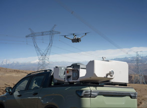
Water treatment works, isolated pipelines, and electrical substations require constant security and structural integrity checks. The DJI Dock 3, paired with the Matrice 4TD enterprise drone, is specifically designed for these 24/7 remote environments. It features an IP56 ingress protection rating on the station and an IP55 rating on the aircraft itself.
This hardware operates seamlessly in temperatures ranging from scorching summer peaks down to freezing winter lows of minus 30 degrees.
The Matrice 4TD integrates wide, medium tele, and infrared thermal cameras alongside a laser range finder. This sensor array allows a single remote operator to run security sweeps, detect thermal anomalies on transformers, and inspect fence lines without sending personnel into hazardous areas.
Manufacturing spec sheets often highlight maximum flight times of 50 minutes. Real-world testing in UK conditions shows a different picture.
Facing a gusty 12 metres per second wind on a damp afternoon in Yorkshire, that flight window shrinks. Expect a realistic operational window of 32 to 35 minutes before the system triggers an automated return-to-home sequence to protect the asset.
The internal climate control system inside the dock cover constantly manages battery temperature. This active cooling and heating ensures the packs charge safely and deploy instantly when an emergency alert triggers.
Dual-dock rotational operations are now supported on a single project site. This allows one aircraft to take off from Dock A, execute a linear inspection across a 10 kilometre radius, and land safely in Dock B.
SORA v2.5 and the UK BVLOS Framework
Flying a drone out of sight of the operator requires a Beyond Visual Line of Sight authorization from the CAA.
Achieving this authorization means navigating the complex Specific Operations Risk Assessment framework. The current UK SORA framework enforces strict rules regarding population density, operational volume geometry, and air risk environments.
You must accurately define your Flight Geography, Contingency Volume, and Ground Risk Buffer.
The lateral and vertical boundaries of these zones must be calculated using exact aviation formulae. Airspeed, pilot reaction times, and the chosen emergency termination method all dictate the final ground footprint. Manual calculation of these stacking zones across a 15 kilometre pipeline route can take an office-bound chief pilot days of unbillable admin work.
The intrinsic Ground Risk Class is determined directly by the maximum population density within your calculated buffer zones.
The historical method of checking population density involved looking at a single grid cell and assuming that headcount was uniform across the square kilometre. This crude approach systematically overstates ground risk for rural asset sites and linear corridors, pushing operations into higher, more restrictive SAIL levels.
Modern compliance relies on the sliding-window kernel density methodology described in JARUS SORA v2.5 Annex F.
This method drops a circular window across your entire flight volume. The radius of this kernel expands or contracts based on your maximum operating altitude. Dronedesk handles this process automatically, querying the European Commission Joint Research Centre population grid and calculating the true maximum density across the realistic lateral dispersion area.
Managing the Admin Hangover of Automated Fleets
Automated hardware creates an invisible mountain of compliance paperwork. Every single flight conducted by the dock must be logged against a specific job, project, and pilot record.
The CAA demands a transparent, auditable trail for every launch.
Leaning over the tailgate of a transit van trying to manually input flight logs or track battery cycle health is a recipe for compliance failure.
Site-specific Risk Assessments and Method Statements must be generated and stored for every operational location. If your calculated flight path changes, your population metrics, air risk data, and safety cases must be instantly updated.
Air Risk Class determination requires cross-referencing your operating altitude against airspace classifications.
The Dronedesk platform automates this branch of the SORA flowchart. It pulls airspace data directly from OpenAIP, identifying active flight restriction zones, military low-flying sectors, and controlled airspace boundaries.
The automated system flags potential hazards based on your exact operational volume. This gives the command centre full visibility before a mission is distributed to the remote base station.
Outdoor assemblies of people within a 1 kilometre radius of your operational volume must be assessed prior to takeoff. Dronedesk runs this check programmatically using a private, self-hosted Overpass API instance.
The software scans for sports stadiums, recreational grounds, and event venues, recording the exact distance and bearing from your site. If an asset patrol route crosses near a local venue, the system flags the hazard, forcing the planner to input written justifications for ground risk mitigations.
Strategic ground risk mitigations like sheltering, operational restrictions, or tactical ground observation can be logged directly into the system. Dronedesk tracks the required robustness levels, reducing your initial ground risk score and calculating your final SAIL level automatically.
The platform generates a point-in-time, submission-ready PDF report containing full kernel density tables and geometric audit trails. This comprehensive documentation directly addresses the queries a CAA assessor would raise, significantly reducing the likelihood of an application being returned for clarification.
Ready to transition your business to autonomous operations? Upgrade your hardware deployment at the Dronedesk Shop and streamline your SORA compliance workflows with Dronedesk enterprise software.