
Jun 22, 2026
Simultaneous LiDAR and Thermal Inspection: Optimising Power Line Work on UK Grids
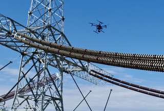
Can a single aircraft collect high-density terrain data and thermal anomaly tracking on a live 400 kV overhead line transmission corridor in one flight? Managing dual-sensor arrays on heavy-lift airframes historically meant mounting custom payloads, balancing frequencies, and struggling through split data logs. The current enterprise framework solves this by supporting simultaneous data acquisition from two independent gimbals on a single flight platform.
Combining raw structural point clouds with precision radiometric data changes how network operators manage asset health. Walking a transmission corridor with a handheld thermal camera and a total station is no longer viable for modern infrastructure timelines. It creates massive unbillable team hours and exposes ground crews to live transmission hazards.
Deploying a dual-gimbal aircraft requires a clear understanding of sensor synchronization and processing limits. Balancing the data output with Civil Aviation Authority compliance requires a systematic approach to operational control.
Dual-Payload Integration on the Matrice Platform
Operating the Zenmuse L2 and Zenmuse H30T together requires the new dual downward gimbal mount. The primary hardware bottleneck for this configuration is total power draw and structural clearance. Running an active frame-based LiDAR system alongside an uncooled microbolometer thermal sensor strains the internal power bus of the platform. The platform handles this by using intelligent power management that prioritises flight controller stability over non-critical payload processes.
Weight management is equally restrictive when planning corridor missions. The Zenmuse L2 weighs approximately 950 grams, and the Zenmuse H30T adds another 920 grams to the nose. This combined payload reduces your practical flight envelope significantly compared to single-sensor setups.
-
Laser Pulse Rate: The L2 emits 240,000 laser pulses per second in standard mapping mode.
-
Thermal Sensor Resolution: The H30T camera provides a 1280 x 1024 radiometric matrix operating at 30 frames per second.
-
Optical Capabilities: The visual camera system features a 40 MP zoom sensor supporting up to 34x optical zoom for close-up component imaging.
-
Laser Rangefinder Integration: The built-in rangefinder measures distances up to 3,000 metres with sub-metre accuracy, feeding real-time coordinates directly to the remote controller.
This high structural density creates an incredible volume of raw information during a standard circuit. Flying a five-kilometre stretch of the electricity distribution grid used to require separate teams for vegetation encroachment mapping and hot-spot asset thermal inspections. Combining these payloads lets you acquire both datasets in half the time, instantly lowering processing overheads.
Ready to build your asset management fleet? Ready to build your asset management fleet? Check out the
. DJI Matrice hardware options at the Dronedesk Shop
Real-World Constraints and the Cynic’s Spec Sheet
DJI documentation quotes a maximum flight time of up to 45 minutes for its flagship platforms. Anyone who has stood beneath a pylon on a freezing winter morning in Scotland knows that actual field conditions invalidate these benchmarks. Carrying almost two kilograms of specialized glass and laser modules while fighting a steady 18-knot headwind limits your safe airtime to 28 minutes before the low-battery triggers activate.
Cold air accelerates battery voltage drops during high-current corridor tracking. Keeping battery packs warm inside the charging case until the exact moment of takeoff is a mandatory field process. The internal heating circuitry inside the intelligent battery station handles this pre-heating automatically, reducing the turnaround time between flight sets.
Varying ground elevation presents a major threat to line-of-sight signal transmission. The aircraft uses its forward and downward obstacle-sensing systems to adjust flight altitude up to 300 metres above the power lines. This real-time terrain tracking maintains a uniform ground sample distance across rolling hills, preventing gaps in the finished point cloud.
Managing the Data Synchronization Process
Relying entirely on separate storage cards can complicate your post-flight workflow. The aircraft handles this by applying unified GPS time stamps across every single photo, thermal frame, and laser echo return. The TimeSync architecture coordinates the internal clocks of both payloads with the onboard RTK positioning module to within a millisecond.
-
RTK Fixed Baseline Accuracy: Delivers 1 cm horizontal and 1.5 cm vertical positioning precision under a continuous satellite lock.
-
Raw Log Separation: The data logs are written to individual memory cards inside the respective payload housings to prevent processing corruption.
-
Network Failover Paths: The remote controller uses cellular data paths to bridge communication gaps if the main video transmission link encounters localized radio frequency interference from high-voltage cables.
Back at the operations office, you import these synchronized raw logs into your processing engine. This eliminates the manual matching of thermal defects to physical structural components. The point cloud provides the exact spatial coordinates for every hot-spot anomaly identified by the H30T thermal sensor.
Processing the Combined Dataset Inside DJI Terra
Transforming raw field logs into actionable engineering files requires an integrated software engine. DJI Terra processes the geotagged images and raw laser data to generate highly accurate orthomosaics and 3D point clouds. The automated alignment engine handles the flight trajectory calculations without requiring manual matching from the technician.
Tagging validation checkpoints or ground control targets inside Terra is highly efficient. You identify a target marker on a single frame, and the computer automatically aligns that marker across all other overlapping visual files. This removes the need for tedious mouse clicks when handling projects containing thousands of high-resolution images.
-
2D Planimetric Generation: Produces clean geotiff orthomosaics that link directly into third-party computer-aided design software.
-
3D Point Cloud Classification: The software automatically separates ground points from vegetation and man-made structures, simplifying encroachment calculations.
-
Quality Reporting Engine: Every automated export creates an extensive flight quality report detailing the root-mean-square error values across your site checkpoints.
Long grass or thick underbrush underneath power line spans often creates major challenges for traditional photogrammetry systems. Because the laser spot size on the L2 is smaller than previous versions, the pulses slip through small gaps in the foliage to hit the bare earth. This high penetration performance ensures you map the actual ground surface instead of the top of the brush layer.
Spending too many unbillable hours fighting with risk assessments and client paperwork? Explore Dronedesk flight planning software to streamline your operations management.
Eliminating the Administration Backlog with Dronedesk
High-performance inspection hardware creates an immense administrative burden. Flying multiple grid utility contracts each week means managing a complex collection of site safety paperwork, flight restriction zone permissions, battery cycle count tracking, and individual pilot currency logs. Neglecting this data trail complicates your annual CAA operational authorisation renewal.
Dronedesk consolidates these separate requirements into a single-screen operations center. The platform monitors your enterprise asset list continuously, tracking battery cycle histories and alerting you to upcoming airframe service deadlines automatically. It imports flight log data, matching the actual flown telemetry to your scheduled inspection tasks without manual data entry.
When building an inspection flight plan inside Dronedesk, the platform checks local airspace restrictions, emergency contacts, and active notice to aviation alerts based on your location coordinates. If an airspace conflict occurs during an automated pylon scan, the crew can document the incident parameters on site. This keeps your central office updated and ensures your utility program remains fully audit-compliant.
Customizing your pre-flight paperwork is straightforward. You configure distinct job profiles for standard utility inspections or complex urban infrastructure projects, activating only the relevant risk modules. This systematic control eliminates guesswork in the field, allowing your remote pilots to focus on capturing clean data rather than managing paper folders.
Long-Term Regulatory and Operational Compliance
Managing a commercial asset-monitoring program requires strict adherence to safety protocols beyond standard stick-and-rudder piloting. Crew resource management principles must be integrated into every utility inspection, defining specific communication responsibilities for the remote pilot and the sensor operator. Clear separation of duties prevents critical errors during low-altitude pylon circuits.
Maintain a permanent, verifiable record of all firmware changes and payload modifications. If you install an auxiliary spotlight alongside your dual downward gimbals, the change in operational weight must be updated in your log records. Dronedesk logs these equipment relationships seamlessly, ensuring your structural documentation matches your actual field deployment.
Maximising Utility Program
Transitioning to a simultaneous LiDAR and thermal workflow provides a major competitive edge for UK inspection firms. It completely removes the need for multiple flight sorties, reduces human exposure to high-voltage hazards, and generates highly accurate engineering models within a short processing window.
Achieving this level of field efficiency requires balancing your asset investments. Upgrading your multi-payload aerial hardware must be supported by a modern management framework that handles your compliance backend.
Supercharge your data collection and eliminate the unbillable paperwork lag today.
. Upgrade your hardware fleet at the Dronedesk Shop and manage your compliance effortlessly with Dronedesk software