
Sep 22, 2026
Scaling Commercial Drone Operations: How the DJI Matrice 400 Redefines Asset Survey Efficiency
What is the true cost-per-hectare of heavy enterprise aerial surveying?
Traditional ground-based surveying and early-generation drone fleets incur significant hidden costs through low flight endurance, redundant battery cycling, and manual administrative overhead. Modern commercial operations require an enterprise platform capable of staying airborne longer while capturing multi-sensor data in a single flight pass.
Operational analysis from Dronedesk shows that scaling commercial drone operations in the UK requires moving away from fragmented, small-scale assets towards integrated heavy enterprise systems. When evaluating large-scale asset inspections and geospatial mapping across utility corridors or mining sites, the financial metrics hinge directly on airtime, coverage speed, and payload capacity.
Legacy setups often require multi-mission flights to capture LiDAR and high-resolution visual photogrammetry sequentially. This dual-pass requirement doubles battery consumption, increases on-site pilot hours, and expands the regulatory risk footprint under UK Civil Aviation Authority (CAA) guidelines.
A heavy enterprise rig must deliver raw efficiency metrics that directly offset capital expenditure through lower operational expenditure per hectare.
-
Airborne Endurance: Extended flight times directly reduce battery rotation pauses, keeping pilots focused on flight path oversight rather than ground logistics.
-
Single-Pass Capture: Combining active sensors like rotating LiDAR with dual high-resolution RGB mapping cameras eliminates duplicate flight paths.
-
Ground Coverage Speed: Higher maximum flight speeds during mission execution dramatically increase the total acreage mapped per flight hour.
-
Data Processing Throughput: Automated data processing pipelines convert point clouds and images into actionable spatial models without manual file manipulation.
How does the DJI Matrice 400 optimize operational productivity?
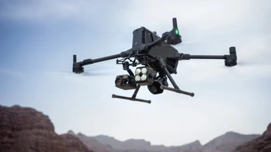
The DJI Matrice 400 enterprise platform delivers up to 59 minutes of flight endurance, a 6 kg payload capacity, and high-speed survey coverage up to 25 metres per second. This combination allows enterprise survey teams to map extensive geographic areas in a fraction of the time required by previous-generation aircraft.
Flight time without payload capacity is a vanity metric when evaluating commercial performance. The Matrice 400 addresses heavy industrial demands by offering a 6 kg payload threshold, allowing complex dual and triple gimbal configurations. Equipped with a next-generation high-capacity battery system and optimized airframe aerodynamics, it maintains extreme stability even in high-wind coastal environments or rugged terrain.
Key hardware metrics of the Matrice 400 platform include:
-
Flight Performance: Maximum flight time up to 59 minutes in forward flight, with maximum mapping and orthophoto route speeds reaching 25 m/s (55.9 mph).
-
Payload Capacity: Supports up to 6 kg total payload weight across multiple SkyPort and E-Port mount configurations.
-
Sensing and Safety: Omnidirectional vision systems paired with a rotating LiDAR and millimetre-wave radar array for advanced obstacle perception.
-
Transmission Range: O4 Enterprise transmission system delivering control up to 40 km, with support for airborne signal relay configurations.
In large-scale topographic mapping or corridor surveys, operational efficiency improves exponentially when flight speed increases from standard 10 to 12 m/s caps up to 25 m/s. Mapping at 25 m/s cuts total site time by more than half while maintaining dense data sampling rates when paired with high-frequency sensors.
The O4 Enterprise transmission system ensures a reliable link across an extended operating range. In complex topographies where terrestrial obstacles block direct line-of-sight signals, the platform supports an airborne signal relay configuration. One Matrice 400 acts as a flying repeater, broadcasting control signals to a secondary operational drone operating behind hills or structural barriers.
Need to upgrade your aerial fleet with maximum endurance and multi-payload capabilities? Explore the new DJI Matrice 400 at Dronedesk Shop for competitive enterprise pricing and technical support.
What sensor configurations deliver the highest data yield per flight?
Pairing the Matrice 400 with the Zenmuse L3 LiDAR system or the Zenmuse H30T multi-sensor payload delivers millimetre-level precision across dense canopy, structural assets, and power corridors. These payloads eliminate field re-visits by capturing high-density point clouds, thermal signatures, and photogrammetric visual imagery in a single pass.
Data highlights confirm that payload selection dictates overall survey accuracy and financial yield. The platform integrates seamlessly with the newest generation of enterprise payloads.
Zenmuse L3 LiDAR System
The Zenmuse L3 uses a 1535nm long-range LiDAR sensor capable of reaching targets up to 950 metres away. Featuring dual 100MP RGB mapping cameras and up to 16 returns per laser pulse, it penetrates dense vegetation to capture bare-earth terrain models beneath heavy forest canopy. Flying at typical altitudes between 300 and 500 metres AGL, a single Matrice 400 flight can cover up to 100 square kilometres per day.
Zenmuse H30T Multi-Sensor Payload
For complex infrastructure, powerline, and structural inspections, the Zenmuse H30T combines five distinct modules: a 40MP zoom camera with 34x optical zoom, a 48MP wide camera, a 3000m laser rangefinder, a near-infrared (NIR) auxiliary light, and a 1280x1024 high-resolution thermal sensor. Onboard foreground stabilization and electronic dehazing keep zoom footage crisp even when inspecting high-voltage pylons in gusting winds.
Integrated Ecosystem Payloads
-
Zenmuse L2: Reliable 5-return frame LiDAR with a 4/3 CMOS RGB camera for cost-effective 3D point cloud generation.
-
Zenmuse P1: Full-frame 45MP photogrammetry sensor featuring a global mechanical shutter and smart oblique capture for large-scale 2D and 3D cadastral mapping.
-
Zenmuse V1 and S1: High-output broadcast speaker and LEP spotlight accessories for night operations and situational awareness.
How do automated workflows streamline field data collection?
Automated flight routing, real-time terrain follow, and onboard AI processing reduce pilot workload while ensuring repeatable, sub-centimetre spatial outputs. These built-in flight intelligence features convert complex manual maneuvers into predictable, software-driven routines.
Field observations show that manual piloting errors are a primary driver of inconsistent survey data. The Matrice 400 leverages an advanced onboard computing platform powered by the Manifold 3 processing unit to execute real-time spatial mapping.
Smart 3D Capture enables the aircraft to perceive unknown 3D environments automatically, mapping structural geometry in real time to generate optimized close-range photogrammetry routes during a single flight. For corridor mapping, the platform follows high-voltage powerlines autonomously, bypassing crossing ground wires using its six-direction millimetre-wave radar and rotating LiDAR obstacle sensing array.
Real-time point cloud previews on the DJI RC Plus 2 controller allow pilots to verify data density and coverage on site before packing up equipment, preventing costly re-flights.
Why is integrated software essential for scaling enterprise fleets?
Hardware capabilities mean little if operational management is crippled by manual administrative tasks, compliance logging, and unorganized safety packs. Scaling a commercial fleet requires pairing enterprise hardware with unified operations software to eliminate unbillable administrative overhead.
Commercial operators spending hours constructing manual flight logs, cross-referencing airspace maps, and generating CAA-compliant Risk Assessment and Method Statements (RAMS) lose their competitive edge. Every minute spent wrestling with spreadsheets or manual compliance documents eats directly into project profitability.
Eliminate manual paperwork, automate flight planning, and maintain audit-ready CAA compliance across your entire enterprise fleet. Start your free trial of Dronedesk Software today.
Dronedesk software acts as the central command center for commercial drone operations. By integrating weather forecasts, NOTAMs, CAA airspace restrictions, and automated pilot currency tracking into a single dashboard, operations managers can generate comprehensive job packs in under five minutes.
For UK operators navigating the UK SORA (Specific Operations Risk Assessment) framework, software automation simplifies population density calculations, intrinsic Ground Risk Class (iGRC) lookups, and Air Risk Class (ARC) assignments. Automatically logging flight data from controllers into central compliance records ensures that risk management, maintenance schedules, and pilot logs remain completely auditable without manual input.
What is the financial return on investment when upgrading fleet assets?
Upgrading to an integrated enterprise solution like the Matrice 400 paired with management software yields a rapid ROI through faster site clearance, reduced labor costs, and lower risk metrics. Capital expenditure is quickly recovered by maximizing billable hours and expanding operational capacity.
Financial metrics highlight a clear contrast between manual ground teams and high-speed heavy aerial survey rigs:
-
Daily Coverage Rates: Traditional ground survey teams average 5 to 10 hectares per day, whereas a Matrice 400 paired with a Zenmuse L3 LiDAR system achieves over 1,000 hectares per day.
-
On-Site Crew Requirements: Ground surveys typically demand 2 to 3 surveyors per site, while heavy drone surveys require only 1 remote pilot and 1 visual observer.
-
Site On-Site Time per 100 Hectares: Manual surveying requires 3 to 5 days on site, compared to under 1 hour of total flight time using a 25 m/s survey path.
-
Administrative & Compliance Overhead: Manual paperwork generation consumes 4 to 8 hours per project, whereas automated Dronedesk job packs compile full RAMS and NOTAM clearances in under 15 minutes.
-
Relative Cost-Per-Hectare: Deploying an integrated enterprise drone solution cuts relative surveying costs down to approximately 15% to 20% of traditional ground team baselines.
Increasing single-flight coverage enables commercial survey firms to bid on massive infrastructure projects that were previously cost-prohibitive. Capturing data at 25 m/s while maintaining real-time terrain follow reduces field labor expenses and improves crew safety in hazardous terrain like open-pit quarries or steep embankments.
Maintaining absolute regulatory compliance via automated flight logging reduces insurance liability and builds operational credibility when pitching for major corporate contracts and tier-one construction tenders.
How to deploy the Matrice 400 within your organization
-
Assess Hardware Requirements: Identify primary payload needs based on core deliverables, choosing LiDAR (Zenmuse L3) for terrain and canopy penetration or multi-sensor optics (Zenmuse H30T) for structural asset inspection.
-
Establish CAA Regulatory Clearance: Ensure operational authorizations cover heavy enterprise aircraft weights and evaluate SORA requirements for complex or BVLOS flight paths.
-
Implement Fleet Software: Integrate Dronedesk to manage pilot certifications, equipment maintenance, RAMS generation, and automated flight log syncing.
-
Develop Pilot Standard Operating Procedures (SOPs): Train flight crews on automated Smart 3D capture, airborne signal relay deployment, and controller-based point cloud quality checks.
-
Optimize Post-Processing Pipelines: Connect captured field data directly into processing suites like DJI Terra for one-click 3D model generation and Gaussian Splatting reconstruction.
Ready to scale your commercial survey operations? Source your high-performance hardware at Dronedesk Shop and streamline your operational compliance with Dronedesk Software.