
Jul 21, 2026
Mavic 3 Enterprise vs Matrice 4 Series: Choosing the Right UK Survey Rig
Operating a lightweight commercial survey airframe under a UK Civil Aviation Authority Operational Authorisation requires balancing strict separation distances against real-world job site efficiency. The 0.7-second mechanical shutter interval on the established Mavic 3 Enterprise has long dictated maximum flight speeds for 1:500 mapping runs. With the arrival of the Matrice 4 Series featuring faster shutter intervals, enhanced video transmission and built-in multi-sensor capabilities, surveyors must decide if upgrading their airframes delivers a measurable commercial return.
The Operational Baseline: Mavic 3 Enterprise Performance
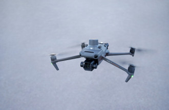
The Mavic 3 Enterprise established the modern standard for compact UK aerial survey workflows. Weighing just 915g, the airframe allows rapid deployment on tight urban sites while maintaining compliance under standard General Visual Line of Sight Certificate (GVC) operational templates.
The 4/3 CMOS 20-megapixel primary sensor incorporates a mechanical shutter capable of 1/2000s speeds. This mechanical shutter eliminates rolling shutter distortion during high-speed automated grid flights. The 0.7-second photo interval allows pilots to maintain an 80% forward overlap while flying at roughly 15 metres per second at standard operating heights.
For most topographic work, a full battery pack yields around 30 to 32 minutes of realistic working time in typical British offshore breeze conditions. That allows a single operator to cover roughly 2 square kilometres per flight at acceptable ground sample distances. The clip-on RTK module maintains centimetre-level positioning when connected to local NTRIP networks or a portable base station.
Key Specs of the Mavic 3 Enterprise:
-
Takeoff Weight: 915g (excluding RTK module)
-
Wide Sensor: 4/3 CMOS, 20MP with mechanical shutter
-
Photo Interval: 0.7 seconds minimum
-
Transmission: O3 Enterprise (up to 8km CE range)
-
Real-world Flight Endurance: 30 to 32 minutes in light wind
What the Matrice 4 Series Brings to the Survey Workflow
The Matrice 4 Enterprise (M4E) increases mapping throughput by shortening image capture intervals and expanding payload capability. Moving from the Mavic form factor to the dedicated compact Matrice airframe brings a noticeable jump in processing power and structural rigidity.
The wide-angle camera retains a 4/3 CMOS 20-megapixel mechanical shutter sensor, but the internal processor cuts the minimum shooting interval down to 0.5 seconds. That 0.2-second reduction sounds minor on paper. In the field, it means the aircraft can fly significantly faster along grid lines while maintaining the exact same forward image overlap.
In addition to the primary mapping camera, the Matrice 4E integrates a 48-megapixel medium telephoto lens (70mm equivalent) and a 48-megapixel telephoto lens (168mm equivalent) alongside an integrated laser rangefinder. The RTK module is built directly into the top of the airframe rather than acting as a bolt-on accessory, reducing setup time on site.
The upgraded O4 Enterprise video transmission system utilizes eight internal antennas. This delivers a maximum download bandwidth of 20MB/s back to the DJI RC Plus 2 Enterprise controller, doubling the data rate of older systems and providing a far clearer live feed around dense structure interference.
Key Specs of the Matrice 4 Enterprise:
-
Takeoff Weight: Approximately 1.2kg with integrated RTK
-
Wide Sensor: 4/3 CMOS, 20MP with mechanical shutter
-
Photo Interval: 0.5 seconds minimum (enabling faster mapping speeds)
-
Integrated Payloads: 20MP Wide, 48MP Medium Tele, 48MP Tele, Laser Rangefinder
-
Transmission: O4 Enterprise with 20MB/s download bandwidth
Real-World Site Efficiency and Data Throughput
Mapping speed on site directly affects how many billable hectares your field crew can cover in a single day. When flying a 10-hectare construction site at 60 metres altitude, the Mavic 3 Enterprise requires a flight speed capped around 12 to 14 metres per second to prevent skipping image captures at a 0.7-second interval.
The Matrice 4E can push horizontal flight speeds up to 21 metres per second while triggering the shutter every 0.5 seconds. On larger linear assets or extensive earthworks sites, this speed increase cuts grid execution times by roughly 25 to 30 percent per battery.
Oblique data capture for 3D structural modelling also receives a major software overhaul on the Matrice 4 Series. The smart 3D capture feature allows three-directional or five-directional oblique image collection in a single automated pass. Rather than executing multiple cross-hatch grid patterns, the airframe tilts its gimbal dynamically while traversing a single path, capturing both vertical and facade detail simultaneously.
Operating in cold weather along UK coastal sites highlights another practical distinction between the platforms. The Matrice 4 Series utilizes higher-capacity batteries with enhanced internal management, providing a stable 35 to 38 minutes of real-world flight time even when battling a 20-knot headwind.
Regulatory and Fleet Management Considerations under UK CAA Rules
Upgrading airframes requires updating your company Operations Manual and managing risk assessments for mixed fleets. Operating either the Mavic 3 Enterprise or the Matrice 4 Series commercially in the UK requires a valid Operational Authorisation granted by the CAA under the GVC framework.
Because both aircraft weigh under 2kg, they operate within similar risk envelopes regarding ground risk buffers and separation distances from uninvolved persons. The extra weight of the Matrice 4 Series (roughly 1.2kg compared to the 915g Mavic 3E) does not push the aircraft into a higher weight category under standard UK Specific Category authorizations, keeping your site separation rules uniform.
Managing a mixed fleet of older Mavic 3 units alongside newer Matrice 4 airframes introduces administrative drag. You must track pilot competency sign-offs on the new RC Plus 2 controller interfaces, keep battery charge cycle logs updated for multiple chemistry types, and ensure firmware updates across all aircraft match your operational approvals.
When managing multiple projects across the UK, manual flight logging and paper-based risk assessments rapidly turn into an administrative hangover. Keeping track of maintenance intervals across different controller ecosystems requires a centralized operational platform to maintain audit readiness.
Making the Final Buying Decision
Choosing between these two airframes comes down to your primary project types and existing fleet density. If your enterprise primarily conducts routine 2D boundary surveys, small housing development mapping, and roof inspections, the Mavic 3 Enterprise remains a capable, highly cost-effective workhorse. Its lower initial capital outlay and ultra-compact transport footprint make it ideal for solo operators moving quickly between urban sites.
If your company handles large-scale earthworks, infrastructure corridors, complex 3D asset modelling, or operates high-frequency flight schedules where every minute on site counts, the Matrice 4 Series justifies the upgrade. The 0.5-second shutter interval, multi-sensor telephoto options, integrated laser rangefinder, and robust O4 video link provide a clear operational edge in demanding environments.
Upgrade your enterprise hardware at the Dronedesk Shop and automate your flight logging, RAMS and CAA compliance using Dronedesk software.