
Aug 11, 2026
How Does the DJI Matrice 400 and Zenmuse H30T Eliminate Power Grid Inspection Downtime?
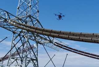
Why Are UK Utility Operators Transitioning to Heavy-Lift Drone Rigs for Grid Inspections?
Unplanned electrical grid outages cost UK distribution network operators millions of pounds annually in emergency repairs and regulatory penalties. Sourcing heavy-lift flight platforms capable of lifting multi-sensor thermal payloads through adverse weather is the fastest way to identify substation degradation before catastrophic failures occur. Replacing manual climbing teams with automated aerial thermography cuts asset downtime while protecting high-voltage maintenance crews from hazardous live-line environments.
High-voltage distribution networks across the United Kingdom face unprecedented strain from aging infrastructure and shifting demand. Substation components such as busbars, isolator switches and transformer bushings develop micro-cracks or elevated resistance hotspots long before physical failure occurs. Traditional thermography relies on ground crews traversing active switchyards with handheld infrared cameras, a method constrained by restricted sightlines and elevated safety risks near live 400 kV conductors.
Manned helicopter sweeps historically provided rapid line coverage across rural transmission corridors, but financial overheads remain prohibitively high. High fuel costs, strict weather windows and airspace coordination requirements limit helicopter deployments to scheduled annual sweeps. This leaves asset managers vulnerable to sudden mid-season failures caused by undetected thermal anomalies.
Deploying commercial unmanned aircraft provides a localized, repeatable alternative for distribution network operators. Smaller aircraft frequently struggle with turbulent weather conditions, severe electromagnetic interference near live conductors and limited payload capacity. Heavy-lift platforms resolve these operational bottlenecks by carrying heavy optical sensors into active electromagnetic fields without losing flight stability or positioning lock.
How Does the DJI Matrice 400 Platform Overcome Substation Environmental Hazards?
The DJI Matrice 400 platform delivers up to 59 minutes of flight endurance and carries up to 6 kg of payload, enabling multi-sensor substation sweeps in a single sortie. Dual RTK positioning antennas bypass reliance on internal magnetic compasses, maintaining centimetre-level flight stability inside active 400 kV electromagnetic fields. Integrated rotating LiDAR and millimetre-wave radar provide omnidirectional, line-level obstacle sensing to prevent collisions with thin conductor wires.
Inspecting active high-voltage substations exposes aircraft to severe electromagnetic fields generated by massive transformers and switchgear. Standard compass systems experience signal drift or total navigation failure when operating in close proximity to high-voltage lines. The Matrice 400 eliminates magnetic compass reliance by integrating dual RTK antennas that supply direct differential positioning data to the flight controller.
Flight endurance directly dictates operational productivity during high-voltage corridor mapping. Reaching up to 59 minutes of forward flight time, the Matrice 400 allows inspection teams to map extensive transmission corridors in a single pass. Extended airtime eliminates constant battery swaps in remote field locations, allowing utility teams to inspect multiple tower structures during a single deployment window.
Weather resilience determines platform availability across harsh UK operational theatres. An IP55 ingress protection rating allows flight operations to continue through heavy rain, wind gusts up to 12 metres per second and ambient temperatures from -20°C to 50°C. Low-noise anti-ice propellers prevent ice accumulation during freezing winter morning inspections when electrical demand is highest.
Signal disruption across hilly terrain or dense urban infrastructure historically caused severe video latency for utility flight crews. The Matrice 400 features an 8-antenna transmission system operating alongside O4 Enterprise Enhanced protocol, delivering stable 1080p live video feeds up to 20 km away in UK airspace. Airborne Relay Video Transmission allows a secondary drone to act as an airborne signal bridge over ridgelines, eliminating line-of-sight signal loss around steep geographical features.
Platform capabilities of the Matrice 400 include:
-
Flight Endurance: Up to 59 minutes forward flight time without payload, maintaining extended hover duration with heavy multi-sensor payloads attached.
-
Maximum Takeoff Payload: 6 kg maximum payload capacity supporting multi-gimbal configurations and third-party compute modules.
-
Obstacle Avoidance System: Integrated rotating LiDAR, top LiDAR module and 6-direction millimetre-wave radar providing power-line-level wire detection.
-
Transmission Range: O4 Enterprise Enhanced system supporting 1080p 60fps live transmission with automatic multi-band frequency switching.
-
Environmental Protection: IP55 dust and water resistance rating for continuous operation in inclement weather conditions.
What Makes the Zenmuse H30T Payload Essential for Thermal Hotspot Detection?
The Zenmuse H30T integrates five specialized optical modules into a single IP54-rated stabilized gimbal, combining high-resolution visual zoom with radiometric thermal sensors. A 1280x1024 thermal camera identifies heat differential anomalies down to micro-degree variations across high-voltage conductors. An integrated 3,000-metre laser rangefinder calculates target distance and precise coordinates in real time, streamlining defect logging for maintenance teams.
Thermal fault identification requires high sensor resolution to isolate tiny components across vast substation structures. The Zenmuse H30T delivers 1280x1024 infrared resolution, providing four times the pixel density of previous generation enterprise thermal payloads. Higher resolution allows pilots to identify loose mechanical bolts or degrading insulator stacks from safe standoff distances exceeding 50 metres, well outside flashover danger zones.
Temperature measurement accuracy determines whether an anomaly requires immediate grid isolation or scheduled routine maintenance. The H30T features radiometric temperature reading across a range from -20°C to 1600°C when equipped with an optional infrared density filter. High-gain and low-gain modes adapt automatically to ambient environmental temperatures, ensuring accurate heat signature capture across summer peak loads and cold winter snaps.
Visual cross-referencing confirms whether a thermal hotspot stems from genuine electrical resistance or solar reflection. The H30T includes a 40MP zoom camera supporting 34x optical zoom and 400x digital hybrid zoom. Inspection teams can read serial numbers on high-voltage transformer bushings or spot hairline fractures on porcelain insulators without repositioning the aircraft closer to live conductors.
Nighttime inspection capability expands operational windows for emergency response teams during sudden power outages. The payload incorporates a Near-Infrared (NIR) auxiliary light paired with full-colour night scene algorithms, illuminating targets up to 100 metres away without emitting visible light. Electronic dehazing and foreground video stabilization maintain steady feeds on zoom lenses when wind buffeting hits heavy sensor housing.
Technical specification metrics of the Zenmuse H30T include:
-
Radiometric Thermal Resolution: 1280x1024 resolution infrared sensor supporting High-Res infrared image mode and multiple color palettes.
-
Optical Zoom Range: 40MP 1/1.8-inch CMOS sensor with 34x optical zoom and 400x digital hybrid zoom with foreground stabilization.
-
Laser Rangefinder Measurement: Target distance measurement from 3 metres to 3,000 metres with real-time latitude, longitude and elevation logging.
-
Night Vision Capabilities: Full-color night scene mode, electronic dehazing and an 850 nm NIR auxiliary light for low-light operations.
-
Expanded Thermal Range: Temperature measurement up to 1600°C using the optional IR Density Filter module for extreme industrial thermography.
How Do Fleet Managers Eliminate Administrative Overhead for Multi-Crew Utility Surveys?
Scaling commercial drone operations across regional utility networks creates significant administrative friction, including site-specific risk assessments (RAMS), pilot currency tracking and CAA compliance auditing. Centralized flight operations management software automates pre-flight airspace checks, hazard mapping and regulatory reporting in under 15 minutes per site. Digital flight logging replaces manual spreadsheets, maintaining an audit-ready compliance trail for regulatory authorities and internal safety boards.
Field teams conducting high-voltage grid surveys operate under strict regulatory scrutiny from the UK Civil Aviation Authority (CAA) and internal utility safety boards. Generating compliant risk assessments for every flight location manually consumes hours of valuable field time. Operators must check airspace restrictions, local ground hazards, emergency contacts and localized weather forecasts before launching a mission.
Data from operational case studies indicates that software automation eliminates manual data entry bottlenecks. Dronedesk aggregates aviation chart overlays, temporary flight restrictions (TFRs), Flight Restriction Zones (FRZs), local hospital contacts and real-time weather metrics into a unified workspace. Field pilots generate complete, audit-ready site documentation in under 15 minutes, allowing field crews to spend more time executing critical inspections.
Managing multi-crew team currencies and asset maintenance schedules presents another friction point for expanding operations. Dronedesk tracks remote pilot flying hours, certification renewal dates, GVC qualifications and equipment maintenance cycles automatically. The system alerts fleet managers when battery sets approach cycle thresholds or when aircraft require scheduled servicing, preventing equipment failures on remote job sites.
Regulatory compliance documentation must remain accessible for post-flight auditing and incident reporting. Dronedesk stores complete flight trajectories, pilot records and risk mitigation justifications in secure cloud storage. Utility directors gain complete visibility across their enterprise fleet, verifying that every flight complies with approved operational authorization limits and UK SORA frameworks.
Key administrative performance gains include:
-
Pre-Flight Planning Speed: Flight planning time reduced from 3 hours to 15 minutes per site by aggregating airspace, weather and local hazard data automatically.
-
Automated Risk Assessments: Automated RAMS generation incorporates site-specific hazards, emergency contacts and CAA compliance checks without duplicate data entry.
-
Fleet Asset Maintenance: Automated battery cycle tracking and equipment servicing alerts prevent hardware downtime across multi-crew operational teams.
-
Audit-Ready Flight Logs: Centralized digital flight logging creates tamper-proof records for CAA audits, insurance compliance and internal safety reviews.
What Is the Operational Workflow for Executing High-Voltage Thermal Sweeps?
Executing precise thermal sweeps across active substations requires a structured, repeatable methodology combining automated route planning with real-time sensor cross-referencing. Pre-planning flight paths inside Dronedesk ensures complete ground risk buffer compliance before arriving on site. Integrating dual RTK lock with thermal radiometric recording captures verifiable temperature differentials across all critical infrastructure assets.
Field execution begins long before arriving at the substation perimeter. Operators deploy Dronedesk to map the Flight Geography, Contingency Volume and Ground Risk Buffer based on the Matrice 400 flight profile. Pre-populating asset metadata and local emergency contacts eliminates guesswork during field deployment.
On-site procedures prioritize safety verification and sensor calibration. Field crews establish a secure takeoff pad outside induction zones, power on the Matrice 400 and confirm dual RTK positioning lock. Bypassing magnetic compass dependency ensures positioning stability before lifting off near active transformers.
Sequential steps for executing high-voltage thermography include:
-
Verify Flight Geography and Safe Standoff: Establish an operational boundary maintaining a minimum standoff distance of 50 metres from live conductors.
-
Confirm Dual RTK Positioning Lock: Power on the platform and verify differential RTK fix on the remote controller to bypass magnetic compass drift.
-
Perform Wide-Angle Thermal Baseline Sweep: Execute an initial pass using the Zenmuse H30T wide camera and 1280x1024 thermal imager to capture global thermal baselines across switchgear.
-
Isolate Anomaly Hotspots with Optical Zoom: Switch to the 34x optical zoom visual camera to cross-reference heat signatures against physical component condition, looking for discoloration or mechanical wear.
-
Log Precise Spatial Coordinates: Trigger the integrated 3,000-metre laser rangefinder to record target distance, GPS coordinates and exact elevation for immediate maintenance dispatch.
What Is the Financial Return on Investment When Automating Grid Inspections?
Automating power grid inspections with heavy-lift drone platforms reduces inspection time per circuit mile by over 60 percent compared to ground foot patrols. Sourcing enterprise hardware via consolidated supply partners eliminates asset downtime through rapid equipment turnover and warranty support. Integrating automated administrative management software saves approximately 45 minutes of unbillable labor per flight, generating immediate operational cost savings.
Financial returns from aerial grid inspections stem from both direct operational savings and avoided downtime costs. Traditional foot patrols require a two-person engineering team to traverse rough terrain, inspecting approximately 3 to 5 transmission towers daily. The Matrice 400 paired with the Zenmuse H30T inspects 20 to 30 towers per day, dramatically reducing labor cost per asset inspected.
Early thermal fault detection prevents catastrophic equipment failure, which can cost network operators hundreds of thousands of pounds in replacement parts and regulatory service penalties. Identifying a failing transformer bushing during routine thermography allows scheduled maintenance during off-peak hours, avoiding emergency shutdown costs and widespread consumer blackouts.
Analysis of field operations demonstrates quantifiable financial advantages for utility contractors:
-
Increased Daily Field Coverage: Inspection output increases from 5 towers daily via manual foot patrols to over 25 towers daily using heavy-lift aerial platforms.
-
Reduced Administrative Labor: Automated pre-flight risk assessment and flight logging save up to 2.5 hours of unbillable administrative labor per pilot per day.
-
Eliminated Maintenance Downtime: Centralized fleet management software identifies battery degradation and hardware service intervals before field failures occur.
-
Reduced Inspection Costs: Overall inspection cost per tower drops by over 50 percent while delivering higher density thermal and visual asset data.
Enterprise hardware procurement requires a clear lifecycle support strategy to maximize asset uptime. Purchasing enterprise flight kits from specialized distributors ensures access to spare parts, rapid replacement units and expert technical guidance. Pairing reliable hardware sourcing with robust operational management software creates a predictable cost structure that scales smoothly across regional fleet deployments.
Dronedesk bridges the gap between enterprise hardware capability and operational compliance, ensuring commercial drone programs deliver maximum commercial value. Sourcing enterprise hardware through Dronedesk Shop while running flight operations on Dronedesk software gives utility managers the ultimate toolkit for reliable, compliant and highly profitable aerial grid inspections.
Equip your enterprise utility fleet with industry-leading hardware and compliance tools. Sourcing enterprise hardware at Dronedesk Shop and managing flight compliance via Dronedesk Software provides a seamless framework for professional aerial inspections.