
Oct 28, 2026
Catchment Runoff Mapping: How to Run the DJI Mavic 3 Multispectral Across Saturated Farmland
Saturated agricultural catchments present a severe operational challenge for UK drone operators. Autumn post-harvest precipitation saturates ground soil, limits line-of-sight access across heavy clay terrain, and accelerates topsoil runoff into sensitive watercourses. Environmental Land Management schemes (ELMs) and Catchment Sensitive Farming grants demand rigorous, auditable spatial data before funding remedial drainage or cover-crop intervention.
Capturing actionable multispectral data across wet arable farmland requires tight sensor calibration, accurate terrain elevation tracking, and disciplined field safety protocols. Operating under unpredictable UK autumn weather windows leaves no margin for administrative friction or poorly calculated flight parameters.
What flight parameters deliver actionable catchment runoff data?
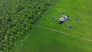
Operating the DJI Mavic 3 Multispectral for hydrologic runoff modelling requires a ground sampling distance (GSD) of 5 cm per pixel or better to detect micro-rills and compaction tracks. This target resolution balances radiometric accuracy with practical battery endurance across large field parcels.
Attaining this resolution requires an operational flight altitude of approximately 130 metres above ground level for the 20MP RGB mechanical shutter sensor, which corresponds to roughly 7.7 cm per pixel on the 5MP multispectral channels. If your objective focuses purely on narrow gully erosion and fine soil migration along headlands, reducing altitude to 75 metres delivers 2.8 cm RGB resolution and 4.3 cm multispectral resolution.
Key flight execution metrics for saturated catchment mapping:
-
Forward and Side Overlap: Maintain 80% forward overlap and 75% side overlap to prevent photogrammetric failure over reflective surface water, muddy tramlines, and low-texture bare soil.
-
Flight Speed Thresholds: Cap transit velocity at 10 to 12 metres per second. While the mechanical shutter operates down to 0.7-second intervals, excessive speed over wet fields increases motion blur during lower-light autumn conditions.
-
Sun Angle Constraints: Restrict mapping sorties to windows where solar elevation exceeds 30 degrees, typically between 10:00 and 14:00 GMT in late autumn, avoiding long hedgerow shadows that invalidate vegetative index calculations.
Need dedicated surveying and multispectral enterprise payloads for seasonal mapping? Explore precision agricultural hardware at the Dronedesk Shop.
How do you configure real-time terrain-following over complex slopes?
Real-time terrain-following keeps sensor resolution consistent across rolling topography, preventing data distortion in valley bottoms where agricultural runoff concentrates. Without terrain tracking, an aircraft maintaining a constant launch-point altitude drifts outside the optimal focal plane, altering the GSD and introducing major stitching errors in photogrammetry engines like DJI Terra.
Terrain elevation changes directly affect your Ground Risk Buffer calculations under UK flight operations. Operators must import an open-source digital surface model (DSM) or digital elevation model (DEM) directly into the remote controller via microSD card prior to departure.
The Pilot 2 interface uses this DSM layer to dynamically adjust the flight ceiling relative to the surface below. In catchments with steep valley gradients or sudden escarpments, standard visual line of sight (VLOS) can degrade rapidly. Setting your takeoff position on high ground ensures you maintain direct visual contact with the aircraft as it descends into lower drainage basins.
How do you maintain radiometric calibration in shifting autumn light?
Shifting cloud cover skews raw reflectance values, making standardisation impossible without continuous incident light logging and calibrated target panels. The DJI Mavic 3 Multispectral integrates an upward-facing solar irradiance sensor that measures ambient lux in real time, writing daylight fluctuation values directly into image metadata.
This onboard sensor compensates for gradual diurnal changes, but it cannot fully account for the rapid light shifts typical of UK autumn skies. Operators must capture images of a calibrated reflectance panel on the ground immediately before launch and immediately after landing.
-
Place the calibration panel flat on open, unshaded ground at least five metres from any vehicles or reflective equipment.
-
Hold the aircraft roughly 1.5 metres above the panel, making sure your own shadow and the landing gear do not occlude the target face.
-
Take manual test exposures on all lenses across both the RGB and multispectral bands.
-
If a heavy cloud front rolls across mid-battery, pause the mission, land to recapture panel baseline data, and resume flight once lighting stabilises.
Data consistency between flights determines whether your Normalised Difference Vegetation Index (NDVI) and Normalised Difference Red Edge (NDRE) maps show genuine soil saturation and vegetative stress or merely transient cloud shadows.
What CAA operational constraints govern wet farmland flights?
Operating multi-rotor aircraft over rural agricultural land does not remove the legal requirement to manage third-party ground risk and dynamic boundary hazards. Under UK Open Category (A3) or Specific Category authorisations, pilots must actively enforce minimum separation distances from uninvolved persons, livestock, and public rights of way.
Public footpaths often cross active UK farmland, and autumnal soil mapping regularly coincides with rambler traffic. Your pre-flight assessment must account for these access routes, alongside nearby livestock that can become agitated by low-level rotor noise.
Operational safety mitigations for wet ground missions:
-
Establish a sterile takeoff and landing zone on hard standing, using a weighted landing mat to stop mud and pooled surface water blowing into optical sensors.
-
Continuously monitor local METAR and TAF feeds for sudden precipitation squalls and shifting gust thresholds, capping flights at a sustained 12 metres per second wind limit.
-
Avoid battery discharge below 25% capacity, as low ambient autumn temperatures accelerate voltage sag during high-throttle manoeuvres against headwinds.
Ditch administrative backlogs and unbillable planning hours. Generate compliant, audit-ready site RAMS in minutes using Dronedesk Flight Planning Software.
How do you manage RAMS and catchment boundary data without paperwork?
Administrative backlogs destroy the thin profit margins of agricultural survey work when planned through fragmented spreadsheets and printed forms. Saturated catchments require dynamic hazard logging, including drainage ditch positions, active slurry spreading, high-voltage overhead lines, and temporary livestock enclosures.
Dronedesk eliminates disconnected mapping tools by consolidating spatial boundary files, NOTAM notifications, local airspace restrictions, and landowners' details into a single workflow.
Field-ready platform features streamline rural operations:
-
Direct KML/Shapefile Ingestion: Import complex farm boundaries directly into the interactive site plan and generate accurate flight geography envelopes and buffer clearances.
-
Live Environmental Layering: Visualise nearby Sites of Special Scientific Interest (SSSIs), nature reserves, and restricted flight zones before arriving on farm tracks.
-
Instant Risk Assessments: Pull live Met Office weather metrics and regional aerodrome contacts straight into your job pack, generating a comprehensive, branded RAMS document in a single click.
Auditable flight logs synced directly from your hardware provide ironclad proof of compliance. When farming clients submit evidence for catchment management grants or environmental compliance reviews, your exported Dronedesk flight packs deliver transparent operational proof.
How do you translate multispectral data into grant-ready runoff reports?
Converting multispectral orthomosaics into actionable runoff models requires isolating topsoil compaction paths from established vegetative cover. Ingest your raw imagery into DJI Terra to construct accurate 2D orthomosaics, digital surface models, and index layers.
NDVI layers isolate bare soil corridors, while NDRE layers detect early waterlogging stress across winter cereal crops before yellowing becomes visible to the human eye. By exporting these layers into hydrological modelling software or GIS platforms, you map surface flow accumulation vectors directly across the digital elevation model.
Field technicians identify where water gathers into destructive micro-torrents, stripping nitrates and topsoil directly into bordering river catchments. Agronomists and farm managers rely on these exact vector maps to position winter cover crops, construct sediment traps, or install sub-surface drainage lines funded through agricultural infrastructure programmes.
Building a profitable commercial drone operation across the environmental and agricultural sectors requires pairing the right hardware with disciplined, automated operational systems. You cannot afford to lose days in the office processing manual paperwork when tight weather windows require your fleet in the air.
Equip your enterprise fleet with precision sensor hardware from Dronedesk Shop and automate your flight compliance, risk assessments, and logging with Dronedesk Software.