
Sep 10, 2026
Beyond Emergency Response: Using the DJI Matrice 4T and AI Detection for Upland Habitat Surveys
How does the Matrice 4T solve thermal resolution limits in ecological mapping?
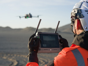
Commercial drone operators across the UK are repurposing public safety thermal hardware to capture lucrative environmental survey contracts. The DJI Matrice 4T integrates a high-resolution 640x512 radiometric thermal sensor, a 48MP wide camera, a 1/2-inch CMOS zoom payload, and an integrated laser rangefinder into a sub-1kg airframe. This multi-sensor configuration enables ecological surveyors to detect thermal signatures from livestock and protected wildlife across rugged UK peatlands, transitioning smoothly from traditional search and rescue tasks to automated species density mapping.
The radiometric thermal camera allows survey teams to identify subtle heat contrast differences against cold background vegetation. Combining thermal imagery with custom AI detection models automates wildlife counting across hundreds of hectares in a single flight pass.
The integrated laser rangefinder pins down precise target coordinates up to 1,200 metres away. This spatial accuracy feeds directly into Geographic Information System (GIS) software, replacing weeks of manual foot patrols over hazardous terrain.
Upgrading your fleet to multi-sensor enterprise airframes expands operational capabilities across public safety and environmental sectors. Source your hardware directly through the Dronedesk Shop to equip your team with mission-ready equipment.
How do you transition search and rescue workflows to environmental monitoring?
Thermal data collection workflows built for search and rescue map directly onto automated habitat survey grids. Operational experience demonstrates that while emergency response requires real-time edge processing, habitat monitoring relies on structured, repeatable flight paths to generate audit-ready datasets.
Key operational insights highlight specific survey parameter standards required for ecological monitoring:
-
Maintain Terrain Following: Set terrain-following flight paths using Digital Elevation Models (DEM) to preserve a constant Ground Sampling Distance (GSD) across elevation changes.
-
Calibrate Thermal Palettes: Use white-hot or ironbow palettes configured to local ground temperatures to maximise contrast against target heat signatures.
-
Configure Flight Overlap: Maintain a minimum of 70% front lap and 60% side lap to facilitate seamless AI object detection processing across adjacent frames.
-
Standardise Survey Timing: Schedule flights during early morning hours when ground thermal inertia is lowest, maximising target-to-background contrast.
How do operators navigate UK CAA regulatory pathways for remote peatland flights?
Executing long-range habitat surveys across remote UK uplands requires clear regulatory planning within the UK Civil Aviation Authority (CAA) framework. Operators must evaluate whether their mission profile fits within the Open category, standard Operating Safety Cases (OSC), or the Specific category via a Specific Operations Risk Assessment (SORA). Managing site risk assessments, airspace classifications, and mandatory documentation manually introduces unbillable administrative friction that scales with fleet size.
Operational framework options for UK upland missions break down across clear categories:
-
Open Category (A3 Subcategory): Suitable for sub-25kg aircraft operating in low-risk, rural areas with no uninvolved people present, maintaining Visual Line of Sight (VLOS) under 120 metres (400 feet) AGL.
-
Specific Category (Pre-Defined Risk Assessments / PDRA): Allows standard operational authorisations for higher-risk profiles using pre-established CAA risk templates.
-
Specific Category (UK SORA 2.5): Necessary for complex, long-range, or automated BVLOS habitat mapping requiring custom Ground Risk Class (GRC) and Air Risk Class (ARC) matrix evaluations.
-
Operating Safety Case (OSC): Required for highly non-standard enterprise operations that fall outside conventional SORA parameters or standard CAA authorisations.
Dronedesk simplifies compliance requirements by centralising data inputs and generating comprehensive site packs for any operational category:
-
Automated Airspace Intelligence: Pull airspace classifications, Flight Restriction Zones (FRZs), and live NOTAMs directly into your digital site plan.
-
Integrated UK SORA Engine: Calculate Ground Risk Class (GRC) and Air Risk Class (ARC) automatically using built-in calculation engines.
-
Audit-Ready Documentation: Generate flight packs, risk assessments, and Method Statements (RAMS) for client review or CAA auditing with a single click.
-
Emergency Action Plans: Pre-populate mandatory emergency contact details, local hospital locations, and air traffic control numbers based on site coordinates.
Manual compliance management creates administrative overhead that drains enterprise profitability. Automate your flight planning, risk assessments, and CAA audit trails effortlessly using Dronedesk Flight Planning Software.
What is the financial ROI of multi-role enterprise hardware deployment?
Deploying a single airframe for both emergency response and environmental surveying optimises capital asset utilisation. Commercial fleets achieve faster equipment payback periods by securing year-round environmental contracts during non-emergency windows.
Dronedesk users say that the automated flight management software reduces their pre-flight planning time from hours to under fifteen minutes per site. This administrative efficiency allows pilots to spend more time executing field missions and generating billable survey outputs.
Maximise Your Enterprise Drone Operations
Enterprise drone operations require a balanced approach combining high-capability hardware with streamlined compliance management software. The DJI Matrice 4T provides the thermal resolution and flight performance needed for complex upland habitat surveys and emergency response missions alike.
Pairing your hardware deployment with automated operational management lets your enterprise team scale flight operations efficiently while maintaining strict adherence to UK CAA regulations.
Equip your operational fleet with the latest DJI Enterprise technology at the Dronedesk Shop
, and eliminate your regulatory admin burden today with . Dronedesk Software