
Jun 17, 2026
Autonomous Operations on the Move: Deploying the Vehicle-Mounted DJI Dock 3 under UK Operational Authorisations
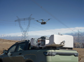
Operating an automated base station from the bed of a moving utility vehicle fundamentally alters remote fleet logistics. The DJI Dock 3 introduces mobile, vehicle-mounted deployment to industrial workflows, moving beyond the constraint of fixed-site installations. This shift from static to dynamic operational launch points introduces severe regulatory challenges under the UK Civil Aviation Authority framework.
Commercial operators must look past manufacturer marketing specifications to understand the precise engineering constraints and the software compliance infrastructure required to legally run these systems within UK airspace.
The Engineering Realities of Mobile Docking
The physical architecture of the enclosure determines its survival rate on remote industrial sites. The station is rated to IP56, providing water and dust ingress protection while securing either a Matrice 4D or Matrice 4TD aircraft inside. The internal climate control system regulates internal components across external temperatures ranging from minus 30 to 50 degrees Celsius. Water run-off is managed by a slanted shell design to prevent ice accumulation on the automated hatches.
Vehicle mounting subjects the internal mechanics to continuous kinetic stress. The internal dampening mounts must isolate the specialized aircraft from road vibration during cross-country transit over rough asset corridors.
The launch sequence is exceptionally rapid. Opening the motorized covers, spinning up the low-noise propellers, and clearing the launch pad takes approximately 10 seconds. The aircraft achieves a vertical climb rate of 10 metres per second, meaning it reaches a standard 100-metre operational altitude within a minute of receiving a remote command via the cloud software.
Wind thresholds limit automated operations far more than thermal barriers. The system can launch and recover the automated aircraft in steady winds up to 12 metres per second. In typical UK coastal environments or exposed linear pipelines, these limits require real-time monitoring to prevent a catastrophic recovery failure on a shifting vehicle platform.
Explore the complete industrial specifications and procurement options for the mobile automated enclosure at the
. Dronedesk Shop
The CAA Compliance Path for Dynamic Launch Sites
Flying an automated drone from an ever-changing mobile position requires an intensive Specific Operations Risk Assessment. The standard Article 11 UK SORA framework is built around static operational volumes with clearly defined coordinates. Moving the base station on a vehicle requires a rolling operational volume that must be dynamically evaluated against regional population densities and local airspace structures.
Determining the Intrinsic Ground Risk Class represents the first major regulatory hurdle. The maximum population density must be assessed across the entire transit corridor using a sliding-window kernel method. This calculation establishes a realistic ground risk footprint based on the aircraft's speed, mass, and operating altitude.
-
Aircraft Mass and Dimensions: The Matrice 4D features a 1.36-metre characteristic dimension with folding low-noise anti-ice propellers, placing it in a distinct risk category from smaller consumer platforms.
-
Ground Risk Buffer: A standard 1:1 rule or a calculated ballistic footprint must be appended to the operational volume to account for potential loss-of-control containment failures.
-
Controlled Ground Area Overrides: If the vehicle is operating within a secured, restricted-access industrial site, the ground risk row can be legally overriden to zero, provided strict access controls are documented verbatim in your operating manual.
Air risk classification presents a separate layer of tracking complexity. The software driving the mission must evaluate intersecting airspace volumes up to the contingency volume ceiling in real time. If the vehicle moves into an area where the operational ceiling cuts into Class D controlled airspace, live air traffic control coordination protocols must be actively managed.
Eradicating the Automated Admin Hangover
Operating an unpiloted system on a 24-hour cycle generates a massive amount of compliance data that must be recorded to remain legally airworthy. The CAA requires precise logging of every single flight hour, component defect, and battery charging cycle. Because there is no pilot physically handling the platform on site, this data collection cannot rely on manual paper entries or detached spreadsheets.
The sheer volume of digital records quickly becomes unmanageable for a single account administrator. Every automated patrol mission creates telemetry data, high-resolution imagery, and maintenance histories that must be consolidated. Without a centralized software foundation, verifying that your remote operations remain compliant ahead of an annual CAA audit is virtually impossible.
Cloud Software Integration and Edge Processing
Remote mission management is directed through an integrated software stack that bypasses standard manual controller inputs. Operators execute automated flight routes, monitor thermal anomalies, and adjust camera parameters directly through a web browser interface. The system supports live video streaming via RTSP feeds that comply with international MISB standards, ensuring secure distribution across corporate networks.
Edge computing capabilities allow the system to process visual data locally before uploading summary packages to cloud storage.
-
Intelligent Change Detection: The automated platform compares current imagery against historical baselines over a fixed timeline to identify structural degradation automatically.
-
Ecosystem Object Recognition: The on-board processor runs custom-trained machine learning algorithms to count vehicles, vessels, or people without human intervention.
-
Transmission Redundancy: A specialized cellular dongle creates a parallel 4G data link, maintaining full command oversight if the standard video transmission faces geographic obstruction.
The platform supports a unique dual-drone rotational deployment model. Two separate enclosures can be mounted to a single commercial utility vehicle, allowing one aircraft to launch immediately while the secondary unit charges its self-heating batteries. This setup guarantees continuous aerial data collection over extended infrastructure networks, provided the site has been cleared of temporary ground hazards.
Strategic Operational Value
Transitioning to automated dynamic operations eliminates the human resource bottleneck that historically limited large-scale aerial surveys. A single remote operator located in a central operations centre can oversee multiple vehicle-mounted systems deployed across different counties. This creates a scalable asset management framework that functions independently of localized team limits.
The true commercial returns are realized through the compression of data timelines. Traditional survey workflows required a technician to collect data, return to an office, and manually pass memory cards to a processing engineer. The mobile automated base station uploads photogrammetry data directly to a processing engine over local high-speed networks, delivering actionable 3D twin models within minutes of touchdown.
Maintaining this level of industrial automation requires an absolute commitment to systematic fleet tracking and rigorous risk mitigation.
Secure your next automated fleet upgrade at the
and enforce flawless CAA compliance across all remote mobile deployments by signing up for Dronedesk Dronedesk Shop