
Jun 16, 2026
Achieving 1:500 Survey Accuracy Without GCPs: The Matrice 4E and DJI Terra Workflow
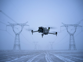
Can a sub-three-pound aircraft really replace a heavy-lift platform for survey-grade photogrammetry on Tier 1 infrastructure projects? For years, achieving true centimeter-level accuracy required hauling heavy gear, layout networks of Ground Control Points (GCPs), and managing massive battery setups. The arrival of the DJI Matrice 4E changes this landscape entirely by packing a proper mapping sensor into a compact, highly portable frame.
When combined with DJI Terra, this setup allows operators to meet strict 1:500 accuracy standards directly from the air. Eliminating the need to walk a active site to paint and log physical targets saves hours of unbillable site prep. It also completely removes the safety risks of staff working near heavy machinery or live highways.
The technical reality of this workflow involves a tightly synchronized hardware and software ecosystem. Managing the data volume and the associated CAA compliance trail requires a systematic approach back at the office.
Inside the Matrice 4E Mapping Payload
Manufacturer spec sheets often hide the practical engineering details that matter to a surveyor working on a blustery engineering site. The wide-angle camera on the Matrice 4E features a 20 MP 4/3-inch CMOS sensor equipped with a proper mechanical shutter. This mechanical shutter eliminates rolling shutter distortion entirely, allowing the aircraft to capture crisp images while traveling at high speeds.
Relying on a standard electronic shutter causes pixel stretching at velocity, ruining your horizontal accuracy during post-processing. The camera trigger speed has been tightened to a rapid 0.5-second interval. This represents a significant step up from the older Mavic 3 Enterprise fleet, which sat at a slower 0.7-second interval.
-
Ground Sample Distance (GSD): Flying at an altitude of 100 meters yields a razor-sharp GSD of approximately 1.2 centimeters per pixel.
-
Shutter Durability: The mechanical shutter mechanism is rated for 500,000 cycles, providing a long operational lifespan for high-volume survey teams.
-
Onboard RTK Integration: The built-in RTK module receives concurrent signals from GPS, Galileo, and BeiDou networks, locking onto a precise position within seconds.
-
Lenses and Focus: The lens features an adjustable aperture ranging from f/2.8 to f/11, maintaining a sharp focus from 1 meter to infinity.
This rapid shutter interval means you can maintain high forward overlaps while increasing the flight speed. Surveying a 150-acre site used to demand an hour and twenty minutes of airborne time. Utilizing the upgraded sensor allows you to trim that flight time down to just 47 minutes without sacrificing data density.
Ready to upgrade your geospatial capabilities? Check out the
. DJI Matrice 4E hardware packages available at the Dronedesk Shop
Real-World Constraints and the Cynic’s Spec Sheet
DJI advertises a maximum flight time of 49 minutes for the Matrice 4E. Anyone who has stood on a muddy embankment in the Midlands knows that real UK conditions eat into that estimate rapidly. Facing a steady 15-knot headwind with a safe battery return buffer means your real-world landing time sits closer to 38 minutes.
Cold weather also introduces major battery voltage drops. Leaning over a vehicle tailgate in a freezing wind trying to swap out packs with numb fingers highlights the value of the new side-cooling duct design. These design updates allow the air-conditioning system inside the transport case to cool or warm the batteries efficiently, reducing the turnaround time between flights.
Varying elevation profiles across valleys or open-cast mines can easily ruin your dataset if your line spacing is fixed. The Matrice 4E utilizes real-time terrain-following paths up to 300 meters, automatically adjusting its height above the ground using its forward and downward fish-eye sensors. This preserves a consistent ground sample distance across the entire project area, ensuring the point cloud remains uniform.
The On-Site Post-Processed Kinematics (PPK) Alternative
Relying purely on a real-time internet RTK stream can be risky when working in remote parts of Scotland or Wales where 4G coverage is non-existent. A dropped network connection mid-flight results in floating RTK coordinates, corrupting the photogrammetry model. The solution is running a localized PPK workflow using a mobile base station.
Pairing the aircraft with the new D-RTK 3 Multifunctional Station allows you to log clean satellite observation data completely offline. The D-RTK 3 functions perfectly as a standalone station over a known point, recording raw RINEX or DAT files for independent post-processing. It also acts as an O4 Enterprise signal relay, maintaining a stable video and data transmission link up to 25 kilometers in challenging, obstructed environments.
-
RTK Fixed Accuracy: Delivers 1 centimeter horizontal and 1.5 centimeters vertical accuracy under a solid network lock.
-
Rover Mode Capability: The D-RTK 3 can be paired with an Android device running the DJI Enterprise app to function as a handheld rover, letting you collect high-precision checkpoints manually.
-
Signal Redundancy: The remote controller supports the new DJI Cellular Dongle 2, providing an automatic backup network path if the primary transmission encounters heavy interference.
Back at the office, you simply import these raw base logs into your processing engine alongside the drone data. This completely bypasses the need for active on-site mobile internet access while guaranteeing sub-centimeter positioning accuracy for every camera trigger location.
Spending too many unbillable hours on site risk assessments and client paperwork? Explore Dronedesk flight planning software to streamline your operations management
Processing the Dataset Inside DJI Terra
Once the flight logs are secured, the raw imagery must be transformed into an actionable digital asset. DJI Terra serves as the primary processing engine, converting the geotagged photos into high-resolution orthomosaics and 3D models. The software features an advanced automation engine that streamlines the initial triangulation step.
Tagging Ground Control Points or validation checkpoints inside Terra is exceptionally fast. You only need to identify and mark a specific target on a single photo, and the algorithm automatically marks that same target across the rest of the overlapping image set. This saves hours of manual mouse clicks when handling large datasets containing thousands of images.
-
2D Orthomosaic Generation: Produces high-precision geotiff files fully compatible with third-party CAD applications like Civil 3D and Trimble Business Center.
-
3D Gaussian Splatting: A new reconstruction method that generates photorealistic, translucent ellipsoids in real time, capturing intricate structural details far better than traditional mesh models.
-
Cluster Computing Support: Terra standard and flagship licenses now include free access to cluster processing, letting you split massive datasets across multiple local computers simultaneously.
-
Quality Reporting: Every export generates an automated survey quality report, detailing the exact vertical and horizontal root-mean-square error (RMSE) values across your checkpoints.
For sites with dense vegetation or long grass, traditional photogrammetry often struggles to find the true bare earth. If your project demands penetrating thick canopy to map a hidden ditch or watercourse, blending this photogrammetry workflow with an aerial LiDAR system like the Zenmuse L3 on a larger Matrice platform becomes necessary. However, for open ground, hardscape, and structural progress tracking, the Matrice 4E photogrammetry output remains superior for fine asset definition.
Curing the Administrative Hangover with Dronedesk
High-performance hardware inevitably creates an unbillable mountain of administration. Flying multiple sites a week means managing a dense web of site RAMS, Flight Restriction Zone (FRZ) permissions, battery cycle tracking, and pilot currency records. Neglecting this data trail puts your CAA Operational Authorisation at serious risk during an audit.
Dronedesk replaces the mess of disconnected spreadsheets and local folders with a unified, single-screen operations center. The platform monitors your assets continuously, flagging upcoming drone maintenance schedules and tracking individual battery health logs automatically. It also connects directly to your DJI account, psynchronises flight logs from the cloud and matches them to the respective jobs.
When building a complex site plan inside Dronedesk, the software automatically populates airspace classifications, nearby emergency contacts, and active NOTAM alerts based on your location coordinates. If an incident or an airspace conflict occurs, your pilots can log the details immediately on site. This keeps your entire team synchronized and ensures your business is always audit-ready.
Varying your operational templates is simple. You can configure custom job types for routine weekly progress scans or complex urban surveys, ensuring only the relevant compliance blocks are active. This disciplined system takes the guesswork out of job planning, allowing your pilots to focus on capturing clean data rather than fighting paperwork.
Maintaining Long-Term Compliance
Surveying with enterprise drones demands strict adherence to safety protocols beyond simple piloting skills. Crew Resource Management (CRM) principles must be integrated into every mission, ensuring team members understand their specific roles during a deployment. Whether utilizing a secondary observer or working solo, structured workflows prevent simple field mistakes from becoming safety hazards.
Keep an auditable record of all equipment modifications and firmware updates. If you attach a third-party payload like a parachute system to the expanding tail ports of the Matrice platform, the change in weight and power distribution must be updated inside your asset logs. Dronedesk tracks these dependencies seamlessly, ensuring your operational documentation reflects your actual field setup.
Elevate Your Geospatial Workflows
Transitioning to the Matrice 4E and DJI Terra workflow provides a clear commercial advantage for UK survey firms. It eliminates the manual grinding of laying out endless ground targets, keeps your staff safe from site hazards, and delivers beautiful, high-accuracy digital twins within a 24-hour turnaround window.
Achieving this level of efficiency requires balancing your investments in both hardware and software. Upgrading your physical fleet must go hand-in-hand with upgrading your back-office compliance systems.
Supercharge your data collection and eliminate the unbillable paperwork lag today.Upgrade your hardware fleet at the Dronedesk Shop and
. manage your compliance effortlessly with the Dronedesk platform.