
Aug 27, 2026
Zenmuse H30T vs Zenmuse L3: Peak District Environmental Conservation Payload Masterclass
Which Flagship Payload Controls Peatland Wildfires and Maps Fragile UK Habitats?
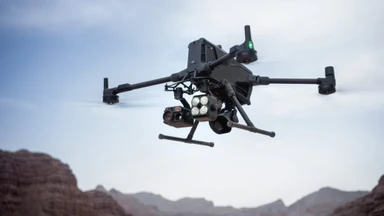
The primary decision factor when choosing between the Zenmuse H30T thermal series and the long-range Zenmuse L3 LiDAR payload on the DJI Matrice 400 is operational objective: real-time thermal AI perception versus sub-centimetre bare-earth canopy penetration. The Zenmuse H30T operates as a multi-sensor thermal suite designed for active wildfire tracking, nocturnal fauna surveys, and emergency response. The Zenmuse L3 utilizes a 1535nm long-range LiDAR engine paired with dual 100MP mapping cameras to penetrate dense moorland bracken, generating precise Digital Elevation Models across vast ecological reserves.
Commercial conservation teams, national park authorities, and emergency services across the UK face strict operational trade-offs when selecting heavy-lift multi-sensor hardware. Choosing between active thermal perception and passive structural laser scanning impacts initial capital expenditure, Civil Aviation Authority Specific Operations Risk Assessment metrics, and daily field logistics.
-
Zenmuse H30T Flagship Payload Specs:
-
Radiometric Thermal Core: 1280x1024 Infrared High-Res mode at 30Hz.
-
Visual Zoom Camera: 40 MP 1/1.8-inch CMOS with 34x optical zoom and 400x hybrid zoom.
-
Visual Wide Camera: 48 MP 1/1.3-inch CMOS with 24mm equivalent focal length.
-
Laser Rangefinder: 3m to 3,000m operating range with real-time Ordnance Survey grid coordinate output.
-
Night Operations: Integrated Near-Infrared auxiliary light and full-color Night Scene mode.
-
Physical Protection: IP54 ingress protection rating operating from negative 20 degrees Celsius to 50 degrees Celsius.
-
-
Zenmuse L3 Flagship Payload Specs:
-
LiDAR Sensor Core: 1535nm Class 1 eye-safe long-range laser engine.
-
Maximum Range: 950m at 10% reflectivity with a 500m maximum operational ceiling above ground level.
-
Point Cloud Output: Up to 2 million pulses per second with up to 16 returns per pulse.
-
Photogrammetry Suite: Dual 100MP mechanical shutter RGB mapping cameras.
-
System Accuracy: 3 cm vertical accuracy and 4 cm horizontal accuracy at 120m above ground level.
-
Platform Requirement: Exclusively compatible with the DJI Matrice 400 platform.
-
Operating across the Peak District National Park presents severe environmental and logistical challenges. High-altitude moorland winds, sub-zero winters, sudden valley fog, and vast areas of unpaved terrain rapidly consume battery reserves. Matching payload physics to your core deliverable ensures operators avoid wasting battery cycles collecting raw data that fails to solve immediate field objectives.
How Does Thermal AI Perception on the H30T Compare to 1535nm LiDAR Scanning on the L3?
Technical evaluations confirm that the Zenmuse H30T provides live, actionable intelligence through heat signature tracking, whereas the Zenmuse L3 generates dense 3D spatial point clouds for post-flight terrain modelling. The H30T excels at identifying live ignition points, locating missing people, and counting wildlife under cover of darkness, while the L3 strips away heavy vegetation to reveal true ground topography.
-
Peak District Operational Scenarios for H30T Thermal AI:
-
Underground Peat Fires: Low Gain mode measures surface heat up to 600 degrees Celsius to locate subterranean hot spots.
-
Search and Rescue: AI Spot-Check automatically identifies and tracks human heat signatures in pitch darkness.
-
Wildlife Monitoring: High-Res Infrared mode detects nesting ground birds without flying below stress thresholds.
-
Night Patrols: The Near-Infrared auxiliary light projects an 850nm beam up to 100m away, invisible to fauna and human eyes.
-
Subterranean peat fires across moorlands burn invisibly beneath damp surface heather, travelling along underground root channels before igniting major surface blazes. The H30T radiometric thermal sensor isolates these deep-seated thermal anomalies, enabling ground crews to direct fire tenders precisely to smouldering zones before flare-ups occur. Foreground stabilization algorithms lock the visual zoom lens onto distant targets, counteracting heavy mountain wind shear even at 34x optical magnification.
-
Peak District Operational Scenarios for Zenmuse L3 LiDAR:
-
Peatland Erosion Mapping: Penetrates dense bracken and heather to map soil erosion channels to sub-centimetre precision.
-
Flood Risk Modelling: Captures true bare-earth elevations across river catchments to model water runoff paths.
-
Forestry Management: 16 returns per pulse analyze canopy structure, measuring tree height and understory density.
-
High-Altitude Surveying: 950m laser range enables efficient mapping flights at 300m to 500m above ground level above steep valley floors.
-
When mapping heavily vegetated peat bogs, traditional visual photogrammetry fails because the camera only sees the top of the heather canopy, creating false elevation models. The 1535nm laser on the Zenmuse L3 fires up to 2 million pulses per second with 16 echo returns. This high pulse density ensures laser beams strike the bare earth beneath thick vegetation layers, outputting accurate terrain data that feeds directly into hydrological models.
What Are the Operational Differences When Mounted to the Heavy-Lift Matrice 400?
Operational data reveals that the DJI Matrice 400 delivers up to 59 minutes of flight time, IP55 weather protection, and rotating millimetre-wave radar obstacle sensing when paired with either payload. The Matrice 400 replaces legacy airframes like the Matrice 350 RTK as the flagship enterprise platform, providing increased power output, O4 Enterprise transmission over a 40km range, and native sub-2G or 4G cellular redundancy.
-
Matrice 400 Performance Parameters with Enterprise Payloads:
-
Flight Endurance: Up to 59 minutes forward flight time when carrying the Zenmuse H30T.
-
Payload Capacity: Supports single, dual, or triple gimbal configurations up to a 6kg maximum payload mass.
-
Transmission Architecture: O4 Enterprise Enhanced transmission with optional Airborne Relay support.
-
Environmental Resistance: IP55 dust and water rating withstanding operational wind speeds up to 12 metres per second.
-
Navigation Safety: Integrated rotating LiDAR and millimetre-wave radar providing power-line-level obstacle detection.
-
Smart Features: Ship-based takeoff and landing, AR projection, and direct integration with Manifold 3 computing units.
-
Deploying heavy payloads over mountainous, signal-obscured terrain like Kinder Scout frequently results in video transmission loss. The Matrice 400 overcomes terrain masking by utilizing Airborne Relay mode. By launching a secondary aircraft to hover above a high ridge line, the relay platform bounces the O4 video signal down into deep valleys, maintaining uninterrupted 1080p live feeds back to the remote pilot or command center.
The Matrice 400 also supports multi-payload configurations. Field teams can mount the Zenmuse H30T alongside auxiliary payloads like the Zenmuse S1 laser searchlight or Zenmuse V1 voice speaker, transforming the aircraft into a complete tactical command and public safety platform in a single deployment.
How Does Payload Mass and Flight Altitude Impact CAA SORA Calculations?
Deploying heavy-lift airframes like the Matrice 400 requires executing a formal Specific Operations Risk Assessment to establish Ground Risk Classes and Air Risk Classes. Higher aircraft takeoff weights and elevated flight ceilings expand the Flight Geography, Contingency Volume, and Ground Risk Buffer, significantly expanding the total operational volume that must be audited.
-
SORA Spatial Parameters for Heavy-Lift Enterprise Flights:
-
Flight Geography: The primary spatial footprint where normal ecological survey operations occur.
-
Contingency Volume: Buffer calculated based on pilot reaction times, wind drift, and system reaction speeds.
-
Ground Risk Buffer: Calculated using 1:1 rule or ballistic trajectory equations based on maximum takeoff weight and velocity.
-
Adjacent Volume: A mandatory 1km to 35km evaluation zone surrounding the Contingency Volume to measure adjacent air risk.
-
Manual calculation of these spatial boundaries over complex, undulating terrain is a major operational bottleneck for commercial fleets. Calculating population density across rural boundaries manually often leads to conservative over-estimations, forcing operations into higher, more restrictive Specific Assurance and Integrity Levels unnecessarily.
-
Automated SORA Calculations Managed Through Software:
-
Querying Copernicus population datasets automatically to establish true Intrinsic Ground Risk Class metrics.
-
Executing sliding-window kernel density algorithms to prevent single-cell population over-estimations.
-
Fetching OpenAIP airspace layers automatically to verify Air Risk Class ratings and local Flight Restriction Zones.
-
Identifying assemblies of people via OpenStreetMap Overpass API integrations within 1km of the operational site.
-
Streamlining this administrative process allows enterprise teams to transition from site arrival to active flight in minutes rather than spending hours managing complex regulatory paperwork.
Manual SORA risk assessments and paper flight logs slow down emergency deployments and invite audit scrutiny. Streamline your CAA compliance, automate SORA spatial calculations, and manage fleet logistics effortlessly with Dronedesk flight planning software.
How Do Fleet Managers Structure Workflow and Data Processing for High-Volume Surveys?
Data management strategies differ significantly between raw radiometric thermal video feeds and multi-gigabyte LiDAR point cloud processing. While the Zenmuse H30T outputs standard MP4 and radiometric JPEG files that can be reviewed instantly on the remote controller or streamed to DJI Flighthub 2, the Zenmuse L3 generates vast datasets requiring specialized post-processing engines.
-
Software Workflow for H30T Thermal and Visual Data:
-
Field Preview: Real-time point and line temperature measurements directly on the RC Plus 2 controller screen.
-
Cloud Streaming: Real-time video feed distribution to off-site command centers via FlightHub 2.
-
Thermal Analysis: Post-flight radiometric temperature processing using official thermal analysis tools.
-
Incident Logging: Instant mapping of PinPoint coordinates to share exact Ordnance Survey grid references with ground teams.
-
When conducting urgent search and rescue or active wildfire monitoring, speed-to-data is critical. The H30T embeds target coordinates directly into visual metadata, allowing operators to generate instant incident maps without waiting for post-flight software rendering.
-
Software Workflow for Zenmuse L3 LiDAR Data:
-
Point Cloud LiveView: Real-time split-screen point cloud accumulation display inside the pilot application.
-
Edge Quality Control: Immediate on-site Task Quality Reports verifying point cloud density and sensor coverage.
-
Primary Processing: One-click PPK trajectory calculation and point cloud generation inside DJI Terra.
-
Model Refinement: Automated ground classification, noise removal, and mesh editing inside DJI Modify.
-
Advanced Rendering: 3D Gaussian Splatting fusion blending 100MP visual imagery with LiDAR point clouds.
-
For large-scale surveying projects, the Zenmuse L3 processes data through a seamless software stack. Raw point clouds are ingested into DJI Terra for microsecond-level time synchronization alignment, then passed to DJI Modify to strip away vegetation and classify bare-earth points automatically. Managing multi-aircraft fleets utilizing both payloads requires strict oversight of battery charge histories, maintenance cycles, and pilot qualification currency. Centralizing these operational records guarantees complete fleet readiness and simplifies CAA audit verification.
Which Flagship Payload Should You Select for Your Environmental Fleet?
Select the Zenmuse H30T if your commercial operations prioritize rapid emergency response, active wildfire detection, nocturnal animal tracking, and multi-sensor thermal flexibility. Select the Zenmuse L3 if your primary output is high-precision topographical surveying, peatland erosion mapping, forestry canopy analysis, and sub-centimetre bare-earth modeling.
Both payloads represent the pinnacle of enterprise sensor engineering when mounted to the heavy-lift DJI Matrice 400 platform. Pairing these advanced hardware platforms with automated cloud management software ensures your operations remain safe, audit-ready, and highly efficient across every mission.
Equip and Manage Your Enterprise Fleet: Source your next enterprise drone, Zenmuse payload, or official accessory at the Dronedesk Shop and streamline your CAA flight planning, RAMS generation, and fleet compliance with Dronedesk software.