
Oct 13, 2026
Maximising Autumn Agricultural Yields: Multispectral vs Thermal Mapping with the DJI Matrice 4 Series
Post-harvest mapping presents a narrow operational window for UK agronomists seeking to assess soil compaction, manage land drainage, and map emerging crop establishment before winter ground frosts set in
Choosing between high-precision RGB visual mapping and high-resolution thermal imaging dictates how effectively an agricultural consultancy can process field data into actionable soil and crop management plans
How does autumn weather impact agricultural drone mapping in the UK?
Autumn survey missions in the UK require hardware capable of handling lower ambient light, reduced solar elevation, and rapidly changing surface moisture
Operating during the post-harvest transition phase means encountering saturated ground conditions, wet stubble, and shorter daylight hours
Deploying aircraft with upgraded low-light sensing and high-speed mechanical shutters ensures data collection remains accurate even during short flight windows
Should agronomists choose the Matrice 4E or Matrice 4T for autumn land surveys?
The choice between the Matrice 4E and Matrice 4T depends on whether an operation prioritises high-accuracy topographic orthomosaics or subsurface thermal anomaly detection
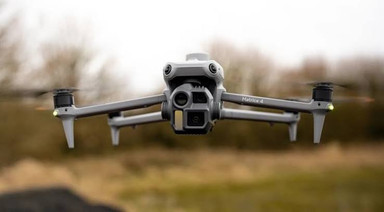
The Matrice 4E features a 4/3 CMOS wide camera with a 20 MP sensor and a mechanical shutter, designed specifically for rapid photogrammetry and high-precision mapping
By contrast, the Matrice 4T integrates an infrared thermal camera with a 640 × 512 resolution (upgradable to 1280 × 1024 in High-Res mode) alongside a 48 MP visual wide sensor
-
Matrice 4E Primary Application: High-speed 2D/3D land mapping, terrain modeling, and boundary mapping
-
Matrice 4E Key Optical Feature: 4/3 CMOS sensor with mechanical shutter preventing rolling-shutter motion blur during fast mapping passes
-
Matrice 4E Survey Rate: 0.5-second image interval for max land coverage per battery cycle
-
Matrice 4T Primary Application: Thermal moisture profiling, land tile drainage inspection, and crop stress detection
-
Matrice 4T Key Optical Feature: Dual 48 MP visual sensors paired with a high-resolution uncooled VOx thermal imager
-
Matrice 4T Thermal Sensor Spec: 640 × 512 radiometric resolution with High-Res mode reaching 1280 × 1024
Sourcing your fleet equipment directly through the Dronedesk Shop ensures UK agricultural operators secure enterprise hardware backed by dedicated technical support and rapid warranty replacement pathways.
How does thermal imaging reveal land drainage and soil moisture anomalies?
Thermal mapping identifies soil moisture variations by recording slight temperature differences on the soil surface caused by water evaporation and thermal mass changes
Following autumn rainfall, saturated soils retain heat differently than well-drained ground
The thermal sensor on the Matrice 4T detects these narrow temperature variations
-
Soil moisture differentials create distinct surface thermal footprints during dawn and dusk cooling cycles
-
Saturated ground appears cooler than surrounding dry soil during daytime solar heating windows
-
Historical land drains alter soil density, leaving detectable thermal lines across bare fields
-
Spot temperature metering in Pilot 2 allows field teams to cross-check exact surface temperature values in real time
Why is high-precision 3D terrain modelling essential for post-harvest soil management?
Generating digital elevation models allows land managers to calculate surface runoff paths, design drainage schemes, and remediate soil compaction
According to technical benchmarks, the Matrice 4E generates millimeter-level ground sample distance (GSD) metrics when flown over post-harvest crop stubble
The resulting Digital Elevation Models (DEMs) and Digital Surface Models (DSMs) processed in DJI Terra display fine elevation shifts across large land parcels
-
Integrated RTK positioning delivers centimeter-level horizontal and vertical spatial accuracy across raw survey data
-
Real-time terrain-follow capabilities ensure the aircraft maintains a consistent height above ground level across rolling hills
-
Photogrammetric point clouds generated in DJI Terra map fine surface contours to highlight compaction zones
-
Exported DEM files load directly into tractor guidance systems for precision subsoiling and variable-rate land grading
Automating administrative workflows and flight record logging with Dronedesk Software cuts risk assessment and compliance overhead from hours down to minutes, keeping agricultural pilots focused on field operations
.
What operational advantages does the Matrice 4 Series offer over legacy agricultural mapping drones?
Upgraded flight efficiency, expanded video transmission range, and built-in AI obstacle sensing significantly improve operational safety and coverage speeds
A key advantage of the Matrice 4 platform is its maximum forward flight speed of 21 m/s (47 mph), allowing operators to survey expansive fields far faster than previous generations
Signal stability across vast rural acreage is maintained by the O4 Enterprise transmission system, supported by high-gain antenna arrays and 4G dongle signal redundancy
-
Max flight speed of 21 m/s reduces total time in the field per mapping task
-
Up to 49 minutes of forward flight time minimizes battery swap cycles
-
O4 Enterprise transmission delivers up to 12 km range under CE standards with 4G fallback options
-
Upgraded low-light fisheye lenses maintain active obstacle avoidance during low-sun and twilight operations
How can agronomists eliminate compliance and administrative friction during busy survey seasons?
Streamlining risk assessments, client documentation, and flight logging into a single management platform prevents administrative bottlenecks
Commercial drone operators flying agricultural contracts often manage dozens of independent land parcels each week
Dronedesk centralises automated weather feeds, airspace hazard mapping, and one-click risk assessment generation into a unified interface
Equipping your fleet with the DJI Matrice 4 Series from Dronedesk Shop alongside Dronedesk Flight Management Software delivers a complete end-to-end ecosystem for enterprise agricultural operations
.