
Nov 11, 2026
Low-Sun Radiometrics: Managing Autumn Thermal Glare and Moisture on High-Voltage Assets
An uncalibrated temperature delta of 5°C on an energised 400kV substation clamp can trigger an emergency outage costing thousands of pounds or leave a degrading bolted joint in service until catastrophic arc flashover occurs. Radiometric thermal surveys across UK high-voltage infrastructure during autumn present unforgiving physical and sensor constraints. When ambient temperatures hover below 8°C and solar angles dip below 20 degrees, low-angle reflectance generates intense radiometric flare while morning condensation creates deceptive conductive cooling across high-voltage conductors.
Capturing defensible aerial thermography across National Grid compounds requires uncompromising technical discipline across sensor physics, automated flight geometry and compliance tracking. Relying on default camera presets under these seasonal variables produces corrupted radiometric data sets that distort maintenance priorities.
Commercial operators must deploy rigorous technical controls across airframe selection, payload configuration and automated flight paths. Here is the operational playbook for capturing defensible thermal data across electrical distribution networks while keeping enterprise documentation audit-ready.
Why does low-elevation solar glare corrupt autumn radiometric thermal data?
Low-elevation autumn sunlight corrugates radiometric thermal readings by creating intense solar reflection across smooth insulator surfaces and bare metallic busbars. This direct specular reflection enters the microbolometer detector directly, driving up apparent surface temperatures and fabricating false-positive delta-T anomalies that do not correspond to electrical resistance faults.
Operational insights show that specular reflection is the single largest cause of abortive utility maintenance work orders between October and December. High-voltage compounds present dense arrays of smooth galvanised steel structures, glazed porcelain or glass insulator strings and bare aluminium terminals. When the sun sits low along the horizon, incident rays strike these low-emissivity surfaces at acute grazing angles, reflecting long-wave infrared energy directly into the sensor optics.
True electrical defects generate uniform, omnidirectional thermal signatures that remain static regardless of your vantage point. Specular reflections produce migratory hotspots whose apparent coordinates shift across the component as the aircraft orbits. Any suspected hotspot must be validated by offsetting your observation point by at least 15 degrees to check whether the anomaly tracks with the solar incidence angle.
The underlying measurement error originates from incorrect emissivity and background temperature values entered into the thermal engine. Radiometric processors calculate object temperature by subtracting reflected ambient radiation from the total energy reaching the sensor array. Setting emissivity to an uncalibrated default of 0.95 across weathered aluminium switchgear with an actual emissivity value near 0.30 forces the internal compensation engine to miscalculate target heat dissipation by up to 25°C.
Thermal validation protocols require taking comparative readings across multiple bearings. Verifying apparent thermal spikes from multiple angles before logging a defect prevents unnecessary emergency site mobilisations.
How does ambient moisture and early morning dew distort electrical hotspot identification?
Surface moisture and dew cause rapid evaporative cooling that masks genuine electrical overheating on energized infrastructure. High relative humidity and saturated autumn air also absorb infrared energy along the flight path, depressing your apparent delta-T measurements across compromised components.
Field data demonstrates that unevaporated condensation on conductor clamps acts as a physical heatsink. A high-voltage disconnector switch with internal contact damage producing 15W of heat dissipation can display an external surface temperature identical to ambient air while surface water is evaporating. Commencing thermal surveys before morning condensation clears leads directly to false-negative inspection reports.
-
Conducting radiometric surveys while dew coats switchgear yields completely inaccurate surface temperatures, meaning flights should focus exclusively on visual defect checks.
-
Running flights once moisture has evaporated provides the most stable atmospheric conditions for genuine delta-T anomaly identification.
-
Relative humidity exceeding 85% causes severe atmospheric path attenuation that depresses long-wave infrared transmission, requiring operations to stop before solar angles drop below 10 degrees.
Key findings reveal that atmospheric moisture attenuation in typical UK autumn weather further distorts data collection over standoff distances exceeding 15 metres. Water vapour in the optical corridor absorbs specific wavelengths within the 8 to 14 micrometre spectral band. Inputting real-time ambient temperature, target distance and relative humidity into payload profiles ensures internal compensation engines retain measurement accuracy.
Convective cooling introduces another significant environmental variable on exposed transmission towers. A sustained 8 m/s autumn crosswind across an overhead line can depress the measured surface delta-T of an overheating compression sleeve by more than 50% compared to dead calm conditions.
How does the DJI Zenmuse H30T resolve autumn utility inspection challenges?
The DJI Zenmuse H30T resolves autumn atmospheric challenges through a 1280×1024 high-resolution radiometric core, active electronic dehazing and an integrated 3,000-metre laser rangefinder. This combination provides the optical resolving power and atmospheric compensation required to survey energised high-voltage infrastructure safely outside the flashover zone.
Older 640×512 thermal sensors force operators to position aircraft dangerously close to live phases to achieve sufficient spot size resolution. The 1280×1024 infrared sensor on the Zenmuse H30T quadruples pixel density on target, allowing pilots to maintain safe physical standoffs while keeping critical assets across at least 3×3 pixels on the thermal matrix.
The uncooled VOx microbolometer achieves a Noise Equivalent Temperature Difference under 50 mK, identifying minute heat differentials across early-stage contact degradation. The built-in 3,000-metre laser rangefinder feeds continuous distance measurements into the thermal calculation algorithm, automating atmospheric transmission corrections in real time. The accompanying 40MP visual zoom camera incorporates active electronic dehazing to cut through dense river valley mists and inspect porcelain sheds for hairline fractures.
Dual-camera integration supports split-screen monitoring within DJI Pilot 2. Remote pilots can cross-examine real-time radiometric feeds alongside high-definition optical streams, matching thermal spikes to physical corrosion marks, burnt paint or mechanical clamp distortion instantly.
Capturing radiometric R-JPEG images allows engineers to conduct detailed post-flight temperature analysis across any point within DJI Thermal Analysis Tool.
Why is the DJI Matrice 400 the benchmark platform for heavy utility missions?
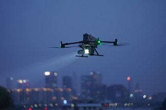
The DJI Matrice 400 delivers an IP55 ingress rating, up to 59 minutes of flight time and an integrated rotating LiDAR and millimetre-wave radar array for power-line-level obstacle sensing. Its heavy-lift architecture provides exceptional flight stability and electromagnetic shielding directly alongside high-voltage transmission lines.
High electromagnetic fields inside transmission substations frequently disable standard commercial electronic compasses. The Matrice 400 circumvents magnetic coupling by using integrated RTK heading antennas, completely ignoring the intense 400kV electromagnetic interference radiating from live transformer banks.
-
The airframe delivers up to 59 minutes of forward flight time, translating to a dependable 42-minute operational window in adverse UK autumn winds while preserving a 20% reserve threshold.
-
Omnidirectional sensing combines rotating LiDAR, upper LiDAR, downward 3D infrared sensors and millimetre-wave radar to deliver active detection around fine conductors and guy wires.
-
The bundled DJI RC Plus 2 controller features a 7-inch daylight-readable screen with 1,400 nits brightness, an IP54 enclosure and hot-swappable external batteries for uninterrupted site operations.
-
O4 Enterprise enhanced video transmission provides multi-channel switching up to 25 km, maintaining control responsiveness through dense steel switchyards.
Carrying multi-payload configurations up to 6 kg, the Matrice 400 handles simultaneous sensor arrays with ease. Operators can deploy the Zenmuse H30T alongside secondary sensors or optical relays to complete visual, thermal and corridor geometry documentation in a single flight sortie.
What flight path parameters eliminate thermal glare during automated missions?
Thermal glare is eliminated by programming automated flight paths perpendicular to the solar azimuth and maintaining an inspection angle between 45 and 60 degrees relative to target surfaces. Automating these waypoints in DJI Pilot 2 guarantees repeatable angles of incidence that avoid direct specular glare.
Data highlights that flying perpendicular to the sun line reflects incident rays away from the camera lens. If the solar azimuth sits at 160 degrees with an elevation of 18 degrees, the aircraft inspection lines must be orientated along an axis between 70 and 250 degrees. This orientation ensures solar rays bounce away into open space rather than striking the sensor face.
-
Avoid scanning vertical insulator strings directly head-on, pitching the gimbal to 50 degrees off-nadir instead to view the component against a consistent ground background rather than a cold sky.
-
Restrict automated survey speeds to 2.5 m/s or lower when capturing high-voltage conductor joints to avoid thermal blur across the microbolometer detector.
-
Maintain a calibrated standoff distance between 15 and 25 metres to satisfy safety isolation boundaries while staying well within the Spot Size Ratio of the Zenmuse H30T.
Executing automated linear routes provides the flight repeatability needed to compare asset degradation over multiple maintenance intervals. Repeat flights capture identical camera poses and pixel distributions year after year, allowing engineering teams to trend delta-T shifts accurately.
Ground markers and check targets must be logged in project coordinates to verify geometric accuracy without setting foot inside energized electrical compounds. Once waypoint routines are verified, the aircraft executes identical sweeps on every scheduled inspection cycle.
How do you build an auditable CAA-compliant utility inspection workflow?
An auditable UK utility inspection workflow requires integrated airspace deconfliction, automated RAMS, precise equipment maintenance tracking and verifiable pilot currency records. Dronedesk replaces fragmented paper binders and spreadsheets with a single, synchronized platform built specifically for UK CAA compliance.
Inspecting high-voltage substations brings operators under immediate regulatory scrutiny. Whether operating under standard GVC permissions or complex Specific Category Operational Authorisations, you cannot afford administrative vulnerabilities. National Grid and regional Distribution Network Operators mandate extensive safety documentation prior to site energisation permits.
Manual flight planning creates dangerous compliance blind spots. Operators often switch between separate tabs for airspace data, Met Office forecasts and hazard mapping, taking up to two hours to build a single site safety pack. Dronedesk consolidates this entire process onto a single screen interface:
-
One-click checks pull live NOTAM data, Flight Restriction Zones and local ground hazards directly into your job plan.
-
Risk assessments and method statements generate automatically based on pre-configured company templates, cutting planning time to under 15 minutes.
-
The platform identifies the nearest accident and emergency facilities, local police stations and air traffic contacts for every substation location automatically.
-
Generate branded, professional compliance packs containing full site maps, pilot accreditations and insurance documents to satisfy utility health and safety audits.
Streamlining site administration ensures remote pilots focus fully on flight safety and sensor calibration in the field. Removing the manual paperwork burden allows operations teams to complete more asset surveys per day without compromising compliance standards.
How do you maintain data integrity and regulatory currency on high-voltage infrastructure?
Data integrity is maintained by synchronizing hardware flight logs with central compliance records and tracking pilot currency over rolling 90-day intervals. Dronedesk automates this lifecycle by linking aircraft telemetry directly to operational asset registers.
High-voltage environments subject flight hardware to harsh operational stress. Sustained electrical fields, vibration and damp autumn conditions degrade motor bearings, propeller structural integrity and gimbal dampeners. Tracking component wear manually across paper logbooks inevitably leads to missed service intervals that invalidate operational insurance policies.
According to Dronedesk operational analysis, operations teams scaling their fleets across multiple utility assets face significant admin backlogs without central data management. Dronedesk solves this by syncing flight logs directly from the cloud the moment the aircraft lands:
-
Every minute flown with the Matrice 400 is instantly assigned to specific serial-numbered battery packs, updating duty cycles and flagging scheduled maintenance intervals.
-
The system automatically verifies that your remote pilots maintain their required two hours of flight time in a rolling three-month window, keeping GVC and operational authorisations valid.
-
If the UK CAA conducts a spot check, Dronedesk generates an end-to-end audit pack showing the complete operational footprint, from initial risk assessment to equipment health histories.
Mastering autumn utility surveys requires combining the right hardware with disciplined operational processes. The Matrice 400 and Zenmuse H30T conquer the physical hurdles of cold weather and radiometric reflection, while systematic software keeps your operations safe and compliant.
Settle your autumn inspection challenges today by sourcing your DJI Enterprise hardware from our shop and automating your operational compliance with Dronedesk flight management software.