
Jul 3, 2026
Advanced Oblique Photogrammetry: Eliminating Re-flights with the Matrice 400 RTK and Zenmuse P1
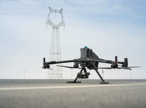
Operating a multi-rotor asset with a takeoff weight of 9.74kg puts your entire business inside the rigorous oversight of a Civil Aviation Authority Operational Authorisation. Flying an industrial asset of this scale near complex structural engineering or high-relief infrastructure means your separation distances must be calculated to the millimetre. Proving to Tier 1 contractors that you can safely manage a heavy-lift system while capturing sub-centimetre data requires moving away from traditional, fragmented planning methods.
The Reality of Full-Frame Data Capture on Irregular Sites
High-relief infrastructure projects like coastal stone revetments or irregular vertical masonry demand an engineering approach to data collection. Standard nadir grids are completely useless when you are tasked with modeling a vertical cliff face or an overhanging bridge abutment. If you rely on cheap, small-sensor equipment, the perspective distortion and lack of mechanical shutter will ruin the reconstruction before the data even reaches your processing machine.
Using the flagship multi-payload platform changes the mathematical foundation of your data capture. The mechanical global shutter of the sensor fires at a speed of 1/2000 seconds. This completely eliminates the pixel distortion common with electronic rolling shutters during high-speed tracking runs.
When you configure this heavy platform for tight corridor operations, the 45-megapixel full-frame sensor provides a massive ground sample distance advantage. You can maintain a safe distance from high-voltage cables or industrial structures while achieving a pixel resolution down to 0.3 millimetres. The massive pixel pitch means you gather more photons per point, reducing the image noise that corrupts point cloud generation in poor British light.
Payload Dampening and Shutter Speed Physics
Heavier sensor packages change how an aircraft responds to the turbulent wind layers found around large UK structures. The 45-megapixel full-frame mapping system requires a highly tuned dampening system to prevent high-frequency motor vibrations from ruining image sharpness. If your payload total weight exceeds 950g, manufacturer data shows the active dampening mechanism lifespan drops from 1000 hours down to 400 hours. This structural degradation is a clear operational cost that must be monitored inside your asset logs.
-
Mechanical Shutter Speed: High-speed mechanical triggering up to 1/2000 seconds eradicates the rolling shutter jello effect completely.
-
Pixel Micron Dimensions: Large full-frame pixels capture massive amounts of light, keeping your shutter fast enough to avoid motion blur on freezing days.
-
Interval Timing Capabilities: Shutter actuation hits intervals as low as 0.5 seconds, meaning your asset can maintain a high forward velocity without missing critical overlap lines.
To get the best technical performance out of your high-accuracy payload, it is worth checking the exact hardware combinations currently available at the
. Dronedesk Shop
Overcoming the Unbillable Paperwork Hangover
Satisfying the stringent compliance requirements of a CAA audit can take longer than the actual site data capture. Commercial clients do not pay for the hours spent typing out risk matrices or checking weather forecasts on three different apps. They expect professional risk assessments and method statements delivered on demand before your wheels turn on their asset.
Managing a multi-pilot team operating heavy commercial systems introduces major fragmentation if you rely on desktop spreadsheets. Tracking individual remote pilot currencies, checking medical expiry dates, and verifying that every airframe has its specific serial numbered maintenance log updated creates an immense administrative burden. This invisible administrative overhead erodes your margins and ties up senior personnel in data entry chores.
Using specialized operations management software turns this regulatory friction into a repeatable system. You can map out your flight geography, contingency volumes, and ground risk buffers on an interactive interface in minutes. Population density checks can be performed using integrated data layers rather than manual guesswork.
If you want to streamline your pre-flight paperwork and clear the administrative backlog, you should explore the automated planning tools over at
. Dronedesk
The Cynic's Spec Sheet Under UK Skies
Manufacturer brochures love to promise a 59-minute flight time for the airframe. Experienced operators know that this number represents a windless environment with pristine battery cells running down to a zero percent state of charge. When you are standing on a freezing hillside in Yorkshire facing a 12 metres per second headwind with a heavy payload hanging off the gimbal, you are looking at a realistic operational limit of 38 minutes.
Swapping battery packs on a tailgate with numb fingers means you need to track cell degradation across the whole fleet. The internal climate control systems inside modern heavy charging stations help, but cold damp conditions will always reduce overall battery longevity.
Advanced Oblique Capture without Re-Flights
Achieving true millimeter-level model fidelity on vertical surfaces requires a five-axis data capture approach. Traditional grid patterns miss the deep recesses of architectural structures or undercuts on complex engineering assets. Using smart oblique capture on your controller allows the gimbal system to automatically tilt and rotate, capturing only the specific angles required for a clean 3D reconstruction.
-
Smart Oblique Capture: The three-axis gimbal dynamically adjusts its pitch during the flight route to capture side profiles of structural elements.
-
Terrain Following Mode: Onboard radar systems adjust the flight altitude relative to the underlying surface, keeping your ground sample distance completely uniform across the site.
-
Data Storage Shifts: High-resolution datasets are written straight to fast CFexpress cards rather than slower micro SD cards, preventing buffer bottlenecks during high-speed imaging.
This systematic approach eliminates the need for expensive site re-visits caused by missing data on obscured faces. Pre-planning your mission parameters ensures that your data sets are ready for seamless importing into photogrammetry processing engines.
Typical Field Mistakes and Immediate Corrections
Losing an RTK fix during an oblique capture sequence usually stems from tall structures blocking your GNSS satellite visibility. If your controller screen drops from a fixed status to a floating status, do not try to continue high-precision mapping missions. You must establish a clear line of sight to an elevated base station or configure an independent network RTK mount point within your controller software before restarting the route.
Another frequent error is running mismatched firmware across your remote controllers, payload gimbals, and the main aircraft. This mismatch triggers unexpected system communication errors that can lock out advanced automated camera functions mid-flight. Always run a full health check inside your operations management dashboard before leaving the office to catch these version mismatches early.
To maintain absolute compliance while upgrading your fleet with the latest commercial hardware, check out the combined software and hardware procurement options at the
. Dronedesk Shop