
Jul 20, 2026
1:500 Accuracy Without GCPs: Real-World UK Benchmark of the DJI Zenmuse P1
Operating a heavy-lift commercial asset under a strict Civil Aviation Authority Operational Authorisation means that every flight parameter must translate directly into billable precision. For tier 1 infrastructure contractors and engineering surveyors across the UK, the traditional requirement to lay dozens of physical Ground Control Points across a live rail corridor or high-risk construction site is a major operational drain. It increases the time boots are on the ground in hazardous environments and drives up unbillable project hours.
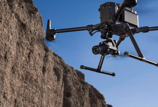
The launch of the DJI Zenmuse P1 promised to rewrite this workflow by delivering sub-3cm horizontal accuracy entirely through an integrated full-frame sensor and microsecond-level clock synchronization. However, operating in volatile British coastal winds or under the typical low-cloud ceilings of an industrial valley requires moving past manufacturer marketing claims to look at real-world data constraints.
The Optical Reality: Full-Frame Microns vs Crop Sensors
The integration of a native 45-megapixel full-frame sensor on a 3-axis stabilized gimbal completely changes the mathematical relationship between flight altitude and Ground Sampling Distance. Unlike smaller 4/3-inch enterprise sensors or older crop-sensor platforms, the P1 utilizes a massive 35.9mm x 24mm sensor window. This structural volume means each individual pixel site spans 4.4 micrometres, providing a substantial increase in light-gathering capability under the flat, overcast lighting conditions typical of winter surveying in the UK.
This sensor footprint allows you to maintain clean signal-to-noise ratios even when flying at high shutter speeds to eliminate motion blur. The optical path is supported by interchangeable DJI DL fixed-focus lenses, with the 35mm lens serving as the standard benchmark for high-accuracy topographic mapping.
Because the sensor is significantly larger, the horizontal field of view expands dramatically. This wider footprint allows you to reduce the number of linear flight paths required to cover a specified layout, dropping side-overlap requirements down to a clean 60% while still satisfying the strict tie-point matching requirements of photogrammetry engines.
-
Older 4/3-inch Crop Sensors: Small pixel sites lead to higher noise in flat, low-contrast UK winter light conditions.
-
Zenmuse P1 Full-Frame: 4.4 micrometre pixel sites ensure clean, high-contrast data even at exceptionally fast shutter speeds.
Deconstructing TimeSync 2.0 and the 1:500 Accuracy Claim
Achieving consistent 1:500 scale cadastral accuracy without relying on physical ground targets demands absolute synchronization between the optical center of the lens and the RTK positioning receiver. Traditional commercial platforms introduce a small millisecond latency between the mechanical shutter trigger and the logging of the GNSS position point. At a standard survey flight speed of 10 metres per second, a tiny 10-millisecond timing error shifts your computed data point by a full 10 centimetres on the ground, entirely corrupting your bare-earth terrain models.
The Zenmuse P1 resolves this spatial shift through the TimeSync 2.0 architecture, which bridges the internal clock modules of the camera, the gimbal, the flight controller, and the onboard RTK receiver at the microsecond level. The exact instant of exposure is recorded precisely at the center of the sensor, embedding a highly accurate three-dimensional coordinate marker directly into the image XMP metadata.
-
Standard Shutter Trigger: Introduces up to 10ms of latency error, creating an unmitigated 10cm horizontal data shift at standard survey speeds.
-
TimeSync 2.0 Clock: Achieves microsecond-level synchronization to lock absolute horizontal precision under 3 centimetres.
When operating with an active Network RTK connection through a reliable NTRIP provider, the system records a fixed vertical and horizontal solution for every image file. This precise positioning loop allows you to secure the centimeter-level absolute accuracy required for Land Registry boundary disputes and formal RICS engineering surveys without needing a two-man ground crew to manually map out physical check targets.
Navigating Real-World UK Flight Planning and Wind Constraints
Executing high-resolution data capture inside busy UK industrial zones requires balancing sensor performance with strict regulatory separation rules. This evaluation shows that while the technical spec sheet implies that the P1 can operate effortlessly at high speeds, real-world data collection requires a much more conservative approach. Pushing the airframe beyond 13 metres per second in typical crosswinds will strain the gimbal motors, introducing subtle micro-vibrations that degrade image sharpness.
To maintain an uncompromised ground sampling distance under 1.5 centimetres per pixel, your pre-flight planning must match your camera trigger intervals perfectly with your ground speed. The P1 features an exceptionally fast 0.7-second continuous shooting interval, allowing you to sustain an 80% forward overlap even when tracking along a steep terrain-following path.
-
Operating Speed: Fixed at 10 to 13 metres per second maximum to protect the gimbal mounts from micro-vibrations.
-
Shutter Speed: Set to a constant 1/2000th of a second global mechanical shutter to entirely eliminate motion blur.
-
Camera Interval: Locked at a 0.7-second continuous shooting rate to maintain an 80% forward overlap.
-
Altitude Mode: Programmed using active terrain-following flight paths to maintain a perfectly consistent GSD over hills.
Managing this data collection process gets complicated when your project area runs along a complex utility corridor or sits underneath a tight Flight Restriction Zone. Manually cross-referencing local airspace ownership, coordinating with Air Traffic Control towers, and designing comprehensive site risk assessments across disconnected systems can create a massive operational bottleneck.
Curing the Post-Flight Data and Compliance Hangover
Operating a high-efficiency sensor like the Zenmuse P1 across multiple commercial assets can generate massive amounts of unbillable office paperwork. A single afternoon of surveying a 3 square kilometre infrastructure site will easily yield over 1,500 raw 45-megapixel image files. This massive volume of field data creates a significant administrative challenge, requiring meticulous tracking of pilot currency hours, detailed platform maintenance schedules, and clear battery charge cycle logging to remain compliant with your CAA audit requirements.
Relying on manual tracking spreadsheets or disconnected folders to manage this information introduces a major compliance liability. If your maintenance tracking slips, a single component failure on a heavy commercial rig can ground your entire team, costing your business significant revenue.
-
Raw Field Capture Phase: Yields more than 1,500 high-resolution images and massive raw data sets per afternoon.
-
Photogrammetry Processing Phase: Feeds directly into engines like DJI Terra to output orthomosaics and 3D meshes.
-
Administrative Compliance Phase: Creates a heavy administrative hangover of flight records, battery lifecycle tracking, and CAA audits.
Dronedesk cures this administrative hangover by centralizing your entire end-to-end commercial operation within a single digital space. The platform syncs seamlessly with your DJI account, automatically importing raw flight records, tracking exact battery serial configurations, and logging precision pilot hours without requiring manual entry.
Instead of wasting unbillable hours building risk assessments from scratch, the platform pulls live meteorological data, maps out current localized airspace constraints, and generates complete, audit-ready site RAMS in less than fifteen minutes. This software loop keeps your operation organized, protected, and focused on delivering high-margin data products.
The Commercial Verdict: Is the P1 the Right Asset for Your Fleet?
For operations managing high-volume topographic surveys, heavy earthwork calculations, or formal cadastral mapping, the commercial return on investment is clear. The combination of the 45MP full-frame sensor and microsecond-level clock synchronization delivers a massive efficiency boost. By removing the requirement to deploy physical ground control points across every project site, you can cut your total field time in half, significantly increasing your weekly project capacity.
If your core business operates primarily within small-scale real estate mapping, basic asset visual checks, or minor stockpile volumes, the smaller Mavic 3 Enterprise remains a highly versatile option. It delivers clean data results without requiring you to invest in a heavy-lift enterprise platform and completely rebuild your existing battery charging infrastructure.
-
High-Volume Engineering / Topographic Surveys: Strongly recommend migrating to the P1 and a dedicated Matrice platform.
-
Small-Scale Stockpiles / Visual Checks: Stick with the smaller Mavic Enterprise ecosystem to avoid unnecessary fleet capital costs.
Ultimately, scaling a professional drone program relies on balancing high-end sensor investments with smart, automated office tracking. Maximizing your data margins means matching your advanced field hardware with an efficient compliance system.
Upgrade your technical fleet capabilities at the Dronedesk Shop and protect your regular compliance workflow using Dronedesk Operations Software.